MAXTON
LAURINBURG/MAXTON (MEB)(KMEB) 3 N UTC–5(–4DT) N34°47.53′ W79°21.95′ 216 B NOTAM FILE MEB
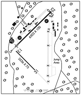
RWY 05–23: H6503X100 (ASPH) S–60, D–160, 2D–256 HIRL
RWY 05: MALSR. PAPI(P4L)–GA 3.0° TCH 52′.
RWY 23: PAPI(P4L)–GA 3.0° TCH 38′. Thld dsplcd 187′. Road. Rgt tfc.
RWY 13–31: H3536X75 (CONC) S–25, D–35
RWY 13: Trees. Rgt tfc.
RWY 31: Trees.
SERVICE: S2 FUEL 100LL, JET A1+ LGT ACTVT MALSR Rwy 05, PAPI Rwy 05–23, HIRL Rwy 05–23–CTAF.
AIRPORT REMARKS: Attended Mon–Fri 1300–2300Z‡, Sat–Sun 1400–2200Z‡. Parachute Jumping. Heavy parachute jumping at south end of clsd Rwy 18–36 and south side of Rwy 13–31. Farming eqpt and mil ops on and invof arpt. For svc after hrs call 910–390–6122 or 315–807–4759. 100LL 24 hr self svc with credit card. Mil acft frqly oper fm clsd ptn of Rwy 13–31 and clsd Rwy 18–36. Rwy 13–31 daylight use only. Rwy 13–31 2750 ft conc stopway on southeast end. No line of sight btn rwy ends. Ctc AMGR for acft rpr svc.
AIRPORT MANAGER: 910-390-6122
WEATHER DATA SOURCES: ASOS 134.125 (910) 844–5338.
COMMUNICATIONS: CTAF/UNICOM 122.8
®FAYETTEVILLE APP/DEP CON 127.8
CLEARANCE DELIVERY PHONE: For CD if una via GCO ctc Fayetteville Apch at 910-484-8012.
RADIO AIDS TO NAVIGATION: NOTAM FILE RDU.
SANDHILLS (L) (L) VORTACW 111.8 SDZ Chan 55 N35°12.93′ W79°35.28′ 160° 27.6 NM to fld. 588/3W.
VOR unusable:
075°–143°
144°–154° blo 6,000′
144°–154° byd 23 NM
155°–179° blo 5,000′
180°–264° blo 8,000′
301°–019° byd 10 NM blo 10,000′
DME unusable:
041°–092° blo 3,000′
TAC AZM unusable:
016°–050° byd 28 NM blo 3,000′
MAXTN NDB (LOM) 257 ME N34°43.99′ W79°26.63′ 055° 5.2 NM to fld.
ILS 110.7 I–MEB Rwy 05. Class IE. LOM MAXTN NDB. LOC unusable byd 16° left of course.