LAWRENCEVILLE–VINCENNES INTL (LWV)(KLWV) 3 NE UTC–6(–5DT) N38°45.86′ W87°36.33′
430 B TPA–See Remarks NOTAM FILE LWV
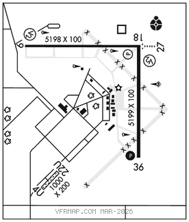
RWY 18–36: H5199X100 (ASPH) S–75, D–100, 2D–180 MIRL
RWY 18: REIL. PVASI(PSIL)–GA 3.0° TCH 25′.
RWY 36: REIL. PAPI(P4L)–GA 3.0° TCH 41′.
RWY 09–27: H5198X100 (ASPH) S–75, D–100, 2D–180 MIRL
RWY 09: REIL. PVASI(PSIL)–GA 3.0° TCH 26′.
RWY 27: ODALS. REIL. PAPI(P4L)–GA 3.0° TCH 26′.
RWY 04U–22U: 1000X200 (TURF)
RWY 22U: Rgt tfc.
SERVICE: FUEL 100LL, JET A LGT ACTIVATE ODALS Rwy 27; REIL Rwy 09, 27, 18 and 36; PAPI Rwy 36; MIRL Rwy 09–27–CTAF. MIRL Rwy 18–36 preset on low intst to incr intst–CTAF. BE ALERT: ODALS for Rwy 27 are in operation simultaneously with REILS on Rwy 18. Rwy 09 and Rwy 18 PVASI unusable byd 8° left of centerline and byd 6° right of centerline.
AIRPORT REMARKS: Attended Mon–Fri 1300–0000Z‡, Sat–Sun 1500–2300Z‡. Glider activity SR–SS. Rwy 09–27 and Rwy 18–36 have left hand tfc pattern for glider acft. Traffic pattern indicators on sod Rwy 04U–22U. TPA–Rwy 09–27 and Rwy 18–36 1330 (900) powered acft, Rwy 04U–22U 930 (500) max ultralights.
AIRPORT MANAGER: 618-943-5733
WEATHER DATA SOURCES: ASOS 118.0 (618) 943–5252.
COMMUNICATIONS: CTAF/UNICOM 122.8
®EVANSVILLE APP/DEP CON 125.6 (1200–0500Z‡)
®INDIANAPOLIS CENTER APP/DEP CON 128.3 (0500–1200Z‡)
CLEARANCE DELIVERY PHONE: For CD when rco 125.6 ots, ctc Evansville Apch at 812-436-4689, when Apch clsd ctc Indianapolis ARTCC at 317-247-2411.
RADIO AIDS TO NAVIGATION: NOTAM FILE LWV.
(T) DME 108.8 LWV Chan 25 N38°46.19′ W87°36.23′ at fld. 430.