MINNEAPOLIS
AIRLAKE (LVN)(KLVN) 22 S UTC–6(–5DT) N44°37.67′ W93°13.69′ 960 B NOTAM FILE LVN MON Airport
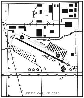
RWY 12–30: H4099X75 (ASPH) S–31, D–47, 2S–102 HIRL
RWY 12: REIL. PAPI(P4L)–GA 3.0° TCH 45′. Railroad. Rgt tfc.
RWY 30: MALSR. PAPI(P4R)–GA 3.0° TCH 36′. Thld dsplcd 392′. Road.
RUNWAY DECLARED DISTANCE INFORMATION
RWY 12: TORA–4099 TODA–4099 ASDA–4099 LDA–4099
RWY 30: TORA–4099 TODA–4099 ASDA–4099 LDA–3707
SERVICE: S4 FUEL 100LL, JET A OX 4 LGT ACTIVATE MALSR Rwy 30; REIL Rwy 12; PAPI Rwy 12 and Rwy 30; HIRL Rwy 12–30 preset to low SS–SR: incr intst and ACTIVATE–CTAF.
NOISE:Voluntary noise abatement procs in efct. See aprt website for more info.
AIRPORT REMARKS: Attended Mon–Fri 1400–0000Z‡, Sat–Sun 1400–2300Z‡. Deer, birds and wildlife on and invof arpt. 100LL self service fuel avbl 24 hrs with credit card. Jet A fuel self serve not avbl. Rwy 30 designated as calm wind rwy. Hangars 400′ north from centerline in primary surface. Rwy 12–30 repainted, displacement on `northwest′ end now taxiway. Ultralight ops prohibited.
AIRPORT MANAGER: 612-726-8140
WEATHER DATA SOURCES: AWOS–3 118.0 (952) 469–5850.
COMMUNICATIONS: CTAF/UNICOM 123.0
FARMINGTON RCO 122.1R 115.7T (PRINCETON RADIO)
®MINNEAPOLIS APP/DEP CON 134.7
MINNEAPOLIS CLNC DEL 118.95
CLEARANCE DELIVERY PHONE: For CD ctc Minneapolis Apch at 612-726-9086.
RADIO AIDS TO NAVIGATION: NOTAM FILE PNM.
FARMINGTON (VH) (H) VORTAC 115.7 FGT Chan 104 N44°37.86′ W93°10.92′ 259° 2.0 NM to fld. 926/6E.
DME unusable:
275°–280° byd 35 NM
305°–315° byd 35 NM
VOR unusable:
235°–240° byd 40 NM
245°–250° byd 40 NM
308°–318° byd 40 NM
TACAN AZIMUTH OTS
TACAN AZIMUTH unusable:
140°–359°
ILS 108.9 I–LVN Rwy 30. Class IB. Unmonitored.