LANCASTER CO–MC WHIRTER FLD (LKR)(KLKR) 4 W UTC–5(–4DT) N34°43.37′
W80°51.28′ 486 B NOTAM FILE AND
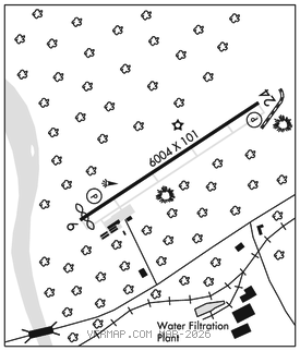
RWY 06–24: H6004X101 (CONC) S–44, D–60, 2D–118 PCN 15 R/B/X/T MIRL 0.4% up NE
RWY 06: REIL. PAPI(P2L)–GA 3.0° TCH 41′. Thld dsplcd 105′. Tree.
RWY 24: REIL. PAPI(P2L)–GA 3.15° TCH 39′. Tree.
SERVICE: FUEL 100LL, JET A LGT ACTVT REIL Rwy 06 & 24; MIRL Rwy 06–24–CTAF. PAPI Rwy 06 and Rwy 24 opr consly.
AIRPORT REMARKS: Attended 1230–2000Z‡. Deer on and invof arpt. For fuel after hrs call 803–285–1513. 25′ drop, 250′ fm thr Rwy 06. Small acft must be on a tie down. Arl applicators not pmtd due to pavement conds. Lndg fee.
AIRPORT MANAGER: (803) 285-1513
WEATHER DATA SOURCES: AWOS–3 120.825 (803) 286–6444.
COMMUNICATIONS: CTAF/UNICOM 122.725
®CHARLOTTE APP/DEP CON 120.05
GCO 121.725 (CHARLOTTE APCH)
CLEARANCE DELIVERY PHONE: For CD ctc Charlotte Apch at 704-359-0241.
RADIO AIDS TO NAVIGATION: NOTAM FILE CLT.
CHARLOTTE (L) (L) VORW/DME 115.0 CLT Chan 97 N35°11.42′ W80°57.11′ 175° 28.4 NM to fld. 732/5W.
DME portion unusable:
015°–050° byd 25 NM blo 3,000′
050°–100° byd 25 NM blo 2,500′
185°–202° byd 15 NM
203°–220°
270°–350° byd 20 NM blo 5,000′
VOR/DME controlled by Charlotte ATCT
VOR unusable:
203°–220°