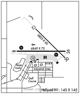
LA JUNTA MUNI (LHX)(KLHX) 3 N UTC–7(–6DT) N38°03.00′ W103°30.59′
4229 B NOTAM FILE LHX

RWY 08–26: H6849X75 (ASPH) S–30, D–50, 2D–90 MIRL 1.1% up W
RWY 08: REIL. PAPI(P2L)–GA 3.0° TCH 45′. Road.
RWY 26: REIL. PAPI(P2L)–GA 3.0° TCH 43′.
RWY 12–30: H5803X60 (ASPH–CONC) S–50, D–65, 2D–100 0.5% up NW
SERVICE: FUEL 100LL, JET A LGT ACTVT PAPI Rwy 08 and Rwy 26–CTAF.
AIRPORT REMARKS: Attended Mon–Fri 1400–2300Z‡. Antelope on and invof arpt. Hvy agricultural opns durg summer months. Self serve Jet A not avbl. Rwy 12–30 sfc raveling with fod potential. Be alert: intensive USAF student training invof Colorado Springs & Pueblo Colorado. Rwy 12–30 has loose asph mtrl in prim sfc west side of rwy full length. Rwy 12–30 edge undefined. See Special Notices–USAF 306 FTG Flight Training Areas, Vicinity of Colorado Springs and Pueblo Colorado.
AIRPORT MANAGER: (719) 384-2698
WEATHER DATA SOURCES: ASOS 135.525 (719) 384–5961.
COMMUNICATIONS: CTAF/UNICOM 123.0
RCO 122.6 (DENVER RADIO)
®DENVER CENTER APP/DEP CON 128.375
CLEARANCE DELIVERY PHONE: For CD ctc Denver ARTCC at 303-651-4257.
RADIO AIDS TO NAVIGATION: NOTAM FILE LAA.
LAMAR (VH) (DH) VORW/DME 116.9 LAA Chan 116 N38°11.83′ W102°41.25′ 245° 39.9 NM to fld. 3944/12E. • • • • • • • • • • • • • • • • • •
HELIPAD H1: H145X145 (ASPH)