RICKENBACKER INTL (LCK)(KLCK) P (ANG ARNG) 10 S UTC–5(–4DT) N39°48.83′ W82°55.67′
744 B TPA–See Remarks LRA ARFF Index–See Remarks NOTAM FILE LCK
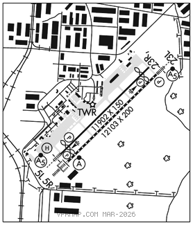
RWY 05R–23L: H12103X200 (ASPH–CONC–GRVD) S–120, D–230, 2S–175, 2D–449, 2D/2D2–973 PCR 708 R/A/W/T HIRL CL
RWY 05R: ALSF2. TDZL. PAPI(P4L)–GA 3.0° TCH 69′. RVR–T
RWY 23L: MALSR. PAPI(P4L)–GA 3.0° TCH 78′. RVR–T
RWY 05L–23R: H11902X150 (ASPH–GRVD) S–120, D–195, 2S–175, 2D–368, 2D/2D2–854 PCR 581 R/A/W/T HIRL
RWY 05L: MALSR. PAPI(P4L)–GA 3.0° TCH 70′. Thld dsplcd 898′.
RWY 23R: REIL. PAPI(P4L)–GA 3.0° TCH 79′. Thld dsplcd 989′.
RUNWAY DECLARED DISTANCE INFORMATION
RWY 05L:TORA–11902 TODA–11902 ASDA–11902 LDA–11004
RWY 05R:TORA–12103TODA–12103 ASDA–12103 LDA–12103
RWY 23L:TORA–12103 TODA–12103 ASDA–12103 LDA–12103
RWY 23R:TORA–11902TODA–11902 ASDA–11902 LDA–10913
SERVICE: S4 FUEL 100LL, JET A, A++ LGT Bdry lgt avbl.
MILITARY– JASU 6(A/M32A–86) 9(B809) 4(AM32–95) FUEL J8(Mil), 100LL, A, A+. FLUID SP PRESAIR LHOX OIL O–128 TRAN ALERT Ltd svc avbl but no PPR rqr. No ANG tran svc off ANG Ramp.
NOISE: Noise abatement proc in efct fm 0400–1200Z‡, DEP Rwy 23L & 23R winds 10 knots or less; ARR Rwy 05L & 05R winds 10 knots or less; arpt ops 614–374–1869.
AIRPORT REMARKS: Attended continuously. Birds on and invof arpt. Class I, ARFF Index B. Index E ARFF equip avbl upon request, ctc arpt opns 614–374–1869. TPA for lgt acft weighing 12,500 lbs or less 1400(656), TPA for acft greater than 12,500 lbs 1900(1156), TPA for overhead tfc 2400(1656). To req ldg rights ctc US Customs between 1230–0300Z‡ Mon–Fri at 614–497–1865. Lndg fee.
MILITARY REMARKS: See FLIP AP/1 Supplementary Arpt Remarks. RSTD AMC acft opr restricted during Bird Watch Conditions Moderate (tkf and ldg permission only when departure/arrival routes avoid identification bird activity, no local IFR/VFR tfc pattern) and Severe (tkf and ldg prohibited without OG/CC approval) ctc Comd Post for current Bird Watch Cond code. All fixed wing military acft requiring parking and/or svc on 121 ARW ramp must have PPR number 48 hr prior from Base OPS DSN 696–4595, C614–492–4595. Base OPS hr vary. Clsd holidays. CAUTION Bird and deer hazard. ANG 121 ARW KC–135–R Comd Post DSN 696–4468. Limited tran svc avbl, weekdays 1200–2000Z‡ except hols. Limited tran fuel/parking, tran aircrew must assist/perform refuel opr. Fuel avbl on ANG ramp on prior request only. Acft support not coordinated by PPR 48 hr prior with 121 ARW may not be avbl. ARNG Opr 1200–2100Z‡ weekdays except hols. No tran svc after 1900Z‡, DSN 346–6411, C614–336–6411. Ctc C–26 OPS prior to entering C–26 ramp/parking area, DSN 346–6473, C614–336–6473.
AIRPORT MANAGER: 614-239-4000
WEATHER DATA SOURCES: AWOS–3 (614) 492–2441
COMMUNICATIONS: ATIS 132.75 UNICOM 122.95
®COLUMBUS APP/DEP CON 134.0 279.6
RICKENBACKER TOWER 120.05 348.4 GND CON 125.275 275.8
CLNC DEL 125.275 275.8
ANG COMD POST 238.8 (Call RICK CON) ARNG OPS 123.09 142.6 228.8 36.7
ARNG C–26 OPS 139.3 (Call TORSO OPS) ARW OPS 238.8 (Call BRUTUS OPS)
AIRSPACE: CLASS D.
RADIO AIDS TO NAVIGATION: NOTAM FILE DAY.
APPLETON (VH) (H) VORTAC 116.7 APE Chan 114 N40°09.06′ W82°35.30′ 224° 25.6 NM to fld. 1354/6W.
VOR unusable:
025°–030°
TACAN AZIMUTH unusable:
075°–095°
110°–115°
DME unusable:
075°–080°
COBBS NDB (LOMW) 253 DD N39°44.58′ W83°01.22′ 052° 6.0 NM to fld. 705/7W. NOTAM FILE LCK.
PICKL NDB (LOMW) 376 LC N39°52.86′ W82°50.16′ 233° 5.9 NM to fld. 764/7W. NOTAM FILE LCK.
ILS/DME 110.55 I–FQS Chan 42(Y) Rwy 05L. Class IE.
ILS/DME 110.1 I–DDV Chan 38 Rwy 05R. Class IIE. LOM COBBS NDB.
ILS 110.1 I–LCK Rwy 23L. Class IE. LOM PICKL NDB. Autopilot cpd apch NA blw 1,000′.
COMM/NAV/WEATHER REMARKS: Ctc GND CTL for CLNC prior to pushback onto Twy A from Cargo Ramp 2. • • • • • • • • • • • • • • • • • •
HELIPAD H1: H50X50 (CONC)