HILLSDALE MUNI (JYM)(KJYM) 2 E UTC–5(–4DT) N41°55.28′ W84°35.20′
1184 B NOTAM FILE JYM
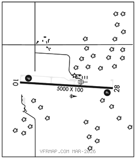
RWY 10–28: H5000X100 (ASPH–GRVD) S–36, D–75 HIRL 0.6% up W
RWY 10: REIL. PAPI(P4L)–GA 3.0° TCH 46′. Tree.
RWY 28: REIL. PAPI(P4L)–GA 3.0° TCH 40′. Tree.
SERVICE: S4 FUEL 100LL, JET A LGT ACTVT REIL Rwy 10 and 28; PAPI Rwy 10 and 28; HIRL Rwy 10–28–CTAF.
AIRPORTREMARKS:Attended Mon–Fri 1300–2130Z‡, Sat 1300–1700Z‡. Unattended major holidays. Deer, lrg birds, and wildlife on and invof arpt. Ctc amgr for snow removal and arpt conds. 100LL avbl H24 via credit card. Jet A fuel truck avbl for sngl point fueling when atndd.
AIRPORT MANAGER: 517-797-4833
WEATHER DATA SOURCES: AWOS–3P 121.025 (517) 437–5638.
COMMUNICATIONS: CTAF/UNICOM 122.8
®TOLEDO APP/DEP CON 134.35
CLEARANCE DELIVERY PHONE: For CD ctc Toledo Apch at 419-865-1495.
RADIO AIDS TO NAVIGATION: NOTAM FILE JXN.
JACKSON (DH) DME 115.45 JXN Chan 101(Y) N42°15.55′ W84°27.51′ 196° 21.1 NM to fld. 994.
DME unusable:
180°–210° byd 30 NM blo 3,500′