JACKSON CO/REYNOLDS FLD (JXN)(KJXN) 2 W UTC–5(–4DT) N42°15.63′ W84°27.73′
1001 B NOTAM FILE JXN
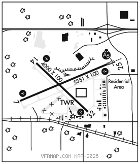
RWY 07–25: H5351X100 (ASPH–GRVD) S–76, D–100, 2D–180 PCN 30 F/C/X/U HIRL
RWY 07: REIL. PAPI(P4L)–GA 3.0° TCH 37′. P–line.
RWY 25: MALSR. PAPI(P4L)–GA 3.0° TCH 45′. Trees.
RWY 14–32: H4000X100 (ASPH–GRVD) S–42, D–62, 2D–115 PCN 16 F/C/X/U MIRL 0.7% up SE
RWY 14: PAPI(P4L)–GA 3.0° TCH 25′. Tree.
RWY 32: REIL. PAPI(P4L)–GA 3.5° TCH 31′. Tree.
SERVICE: S4 FUEL 100LL, JET A+ LGT When ATCT clsd ACTVT MALSR Rwy 25; REIL Rwy 07 & 32; PAPI Rwy 07, 25, 14 & 32; HIRL Rwy 07–25; MIRL Rwy 14–32–CTAF.
AIRPORT REMARKS: Attended Mon–Fri 1300–2200Z‡, Sat–Sun 1300–2000Z‡. Deer and birds on and invof arpt. 100LL and Jet A+ avbl on self svc main ramp. Acft taxing up Twy D could possibly miss the turn for Twy A and violate the safety zone for Rwy 07–25. Low alt hel ops prohibited invof prison 4 mi NE. Winter ficons unmon when ATCT clsd.
AIRPORT MANAGER: 517-788-4225
WEATHER DATA SOURCES: ASOS (517) 768–7506
COMMUNICATIONS: CTAF 128.475 ATIS 125.725 UNICOM 122.95
RCO 122.2 (LANSING RADIO)
®GREAT LAKES APP/DEP CON 127.3 (1030–0500Z‡)
®CLEVELAND CENTER APP/DEP CON 120.45 (0500–1030Z‡)
TOWER 128.475 (1200–0200Z‡) GND CON 121.9 CLNC DEL 121.9
CLEARANCE DELIVERY PHONE: For CD when ATCT clsd ctc Great Lakes Apch at 269-459-3345, when Apch clsd ctc Cleveland ARTCC at 440-774-0224/0490.
AIRSPACE: CLASS D svc 1200–0200Z‡; other times CLASS E.
RADIO AIDS TO NAVIGATION: NOTAM FILE JXN.
(DH) DME 115.45 JXN Chan 101(Y) N42°15.55′ W84°27.51′ at fld. 994.
DME unusable:
180°–210° byd 30 NM blo 3,500′
ILS 109.1 I–JXN Rwy 25. Class IC. Unmonitored when twr clsd.