JACKSON
JULIAN CARROLL (JKL)(KJKL) 3 NE UTC–5(–4DT) N37°35.63′ W83°19.03′ 1381 B NOTAM FILE JKL
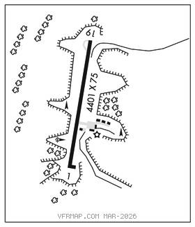
RWY 01–19: H4401X75 (ASPH) S–12.5 MIRL 0.6% up N
RWY 01: REIL. Trees.
RWY 19: REIL. Trees.
SERVICE: LGT ACTVT REIL Rwy 01 & 19; MIRL Rwy 01–19–CTAF.
AIRPORT REMARKS: Unattended. Rwy 01–19 markings faded and algae covered.
AIRPORT MANAGER: (606) 568-5356
WEATHER DATA SOURCES: ASOS 118.375 (606) 252–3918.
COMMUNICATIONS: CTAF/UNICOM 122.8
®INDIANAPOLIS CENTER APP/DEP CON 126.575
CLEARANCE DELIVERY PHONE: For CD ctc Indianapolis ARTCC at 317-247-2411.
RADIO AIDS TO NAVIGATION: NOTAM FILE LOU.
HAZARD (L) DME 111.2 AZQ Chan 49 N37°23.48′ W83°15.78′ 348° 12.4 NM to fld. 1243. monitored by aocc 24 hrs
DME unusable:
012°–040° byd 30 NM blo 4,000′
260°–305°
350°–012° byd 30 NM blo 4,500′