LINCOLNTON
LINCOLN CO RGNL (IPJ)(KIPJ) 5 E UTC–5(–4DT) N35°28.99′ W81°09.69′ 878 B NOTAM FILE IPJ
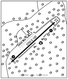
RWY 05–23: H5700X100 (ASPH) S–30, D–60 MIRL 0.3% UP SW
RWY 05: REIL. PAPI(P2L)–GA 3.4° TCH 64′. Thld dsplcd 200′. Trees.
RWY 23: REIL. PAPI(P2L)–GA 3.0° TCH 47′. Thld dsplcd 199′. Trees.
SERVICE: S4 FUEL 100LL, JET A1+ OX2, 4 LGT To ACTVT REIL Rwy 05 & 23 dusk–dawn–CTAF; to ACTVT PAPI Rwy 05 & 23–CTAF. MIRL Rwy 05–23 dusk to 0300Z‡ preset low intst; to incr intst dusk to 0300Z‡ and to ACTVT MIRL Rwy 05–23 between 0300Z‡–dawn–CTAF.
AIRPORT REMARKS: Attended Apr–Oct 1300–0000Z‡, Nov–Mar 1300–2200Z‡. Unattended Thanksgiving and Christmas Day. Deer, coyote and birds on and invof arpt. Rwy 23 has a 90 ft drop–off 100 ft fm pvmt end and 90 ft drop–off first 200 ft 160 ft both sides of cntrln. 200 ft swy SW end has been remarked as 200 ft dsplcd thr for Rwy 05.
AIRPORT MANAGER: 704-764-1100
WEATHER DATA SOURCES: AWOS–3 119.675 (704) 735–6954.
COMMUNICATIONS: CTAF/UNICOM 123.05
®CHARLOTTE APP/DEP CON 134.75 CLNC DEL 124.9
GCO 124.9 (CHARLOTTE APCH) (Key mike 4 times slowly, wait for dial tone and ring)
CLEARANCE DELIVERY PHONE: For CD if una via GCO ctc Charlotte Apch at 704-359-0241.
RADIO AIDS TO NAVIGATION: NOTAM FILE CLT.
CHARLOTTE (L) (L) VORW/DME 115.0 CLT Chan 97 N35°11.42′ W80°57.11′ 335° 20.3 NM to fld. 732/5W.
DME portion unusable:
015°–050° byd 25 NM blo 3,000′
050°–100° byd 25 NM blo 2,500′
185°–202° byd 15 NM
203°–220°
270°–350° byd 20 NM blo 5,000′
VOR/DME controlled by Charlotte ATCT
VOR unusable:
203°–220°
ILS/DME 111.15 I–IPJ Chan 48(Y) Rwy 23. Class IB.