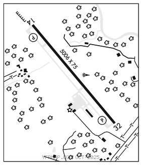
BEDFORD CO (HMZ)(KHMZ) 4 N UTC–5(–4DT) N40°05.17′ W78°30.81′
1162 B NOTAM FILE AOO

RWY 14–32: H5006X75 (ASPH) S–38, D–60, 2D–100 MIRL
RWY 14: REIL. PAPI(P2R)–GA 3.0° TCH 41′. Rgt tfc.
RWY 32: REIL. PAPI(P2L)–GA 4.0° TCH 53′.
SERVICE: S4 FUEL 100LL, JET A OX 1 LGT ACTIVATE MIRL Rwy 14–32; REIL Rwy 14 and Rwy 32–CTAF. PAPI Rwy 14 and Rwy 32 opr consly. REIL ACTIVATE only with 3, 5 or 7 clicks.
AIRPORT REMARKS: Attended Mon–Fri 1300–2130Z‡, Sat 1300–2130Z‡, Sun 1300–2130Z‡. For svc after hrs ctc 814–494–0929. High terrain (mountain ridges) southeast of arpt lgtd with red obstruction lgts. Ldg fee for all acft except light single engine with fuel purchase.
AIRPORT MANAGER: 814-623-0704
WEATHER DATA SOURCES: AWOS–3 123.675 (814) 623–2936.
COMMUNICATIONS: CTAF/UNICOM 122.7
®JOHNSTOWN APP/DEP CON 121.2 (1200–0400Z‡) or ctc 814–532–5960.
®CLEVELAND CENTER APP/DEP CON 124.4 (0400–1200Z‡) or ctc Cleveland ARTCC 440–774–0234.
CLEARANCEDELIVERY PHONE:For CD ctc Johnstown Apch at 814-532-5960, when Apch clsd ctc Cleveland ARTCC at 440-774-0213.
RADIO AIDS TO NAVIGATION: NOTAM FILE AOO.
ST THOMAS (L) TACAN Chan 97 THS (115.0) N39°55.99′ W77°57.06′ 297° 27.5 NM to fld. 2338/7W.