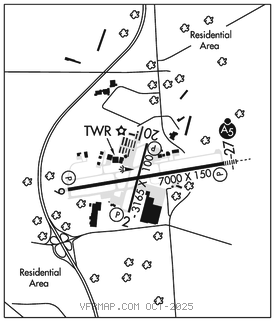
HAGERSTOWN RGNL/RICHARD A HENSON FLD (HGR)(KHGR) P (AR) 4 N UTC–5(–4DT)
N39°42.51′ W77°43.59′ 703 B ARFF Index–See Remarks NOTAM FILE HGR

RWY 09–27: H7000X150 (ASPH–GRVD) S–100, D–150, 2S–175, 2D–250 PCR 750 F/A/X/T HIRL 0.3% up E
RWY 09: REIL. PAPI(P4L)–GA 3.0° TCH 55′.
RWY 27: MALSR. PAPI(P4L)–GA 3.0° TCH 55′.
RWY 02–20: H3165X100 (ASPH) S–80, D–100, 2S–127, 2D–170 PCR 600 F/A/X/T MIRL 0.3% up N
RWY 02: REIL. PAPI(P2L)–GA 4.0° TCH 53′.
RWY 20: REIL. PAPI(P2L)–GA 4.0° TCH 33′.
RUNWAY DECLARED DISTANCE INFORMATION
RWY 02: TORA–3165 TODA–3165 ASDA–3165 LDA–3165
RWY 09: TORA–7000 TODA–7000 ASDA–7000 LDA–7000
RWY 20: TORA–3165 TODA–3165 ASDA–3165 LDA–3165
RWY 27: TORA–7000 TODA–7000 ASDA–7000 LDA–7000
SERVICE: S4 FUEL 100LL, JET A OX1, 2, 3, 4 LGT When ATCT clsd ACTVT MALSR Rwy 27; REIL Rwy 09; HIRL Rwy 09–27–CTAF. MILITARY– FUEL A, A+ (Avbl 1000–0300Z‡, C301–791–9119, OT 3 hr PN C301–730–4700301–730–4100, fee $100hr.) (NC–100LL) OIL O–128
AIRPORT REMARKS: Attended 1000–0300Z‡. Airport unattnd 0300–1000Z‡. Birds on and invof arpt. Ultralight act 12 NM east to 5000′ MSL. Low level mil acft 10 NM north on VR708 operating east to west. Fuel avbl 1000–0300Z‡, call 301–791–9119. DOD contract fuel avbl. Rwy 02–20 CLOSED when ATCT clsd. Class I, ARFF Index B. ARFF Index C avbl upon req; ctc amgr. PPR 24 hrs for unsked acr opns with more than 30 psgr seats call amgr 240–313–2764. Rwy 02–20 clsd to sked acr ops with more than 9 pax seats and non sked acr ops with more than 30 pax seats excp for taxi. PPR 24 hr prior to aces the museum apn. For more info ctc museum mgr at 240–520–3417. Twy P not avbl for air carrier ops. Ldg fee.
AIRPORT MANAGER: 240-313-2764
WEATHER DATA SOURCES: ASOS 126.375 (301) 745–3497.
COMMUNICATIONS: CTAF 120.3 UNICOM 122.95
®POTOMAC APP/DEP CON 126.825
TOWER 120.3 (1200–0300Z‡) GND CON 120.8
CLEARANCE DELIVERY PHONE: For CD when ATCT is clsd ctc Potomac Apch at 866-709-4993.
AIRSPACE: CLASS D svc 1200–0300Z‡; other times CLASS E.
RADIO AIDS TO NAVIGATION: NOTAM FILE HGR.
(L) VORW 109.8 HGR N39°41.86′ W77°51.34′ 091° 6.0 NM to fld. 563/7W.
VOR unusable:
251°–280° byd 16 NM blo 4,000′
281°–300° byd 24 NM blo 8,000′
351°–050°
ST THOMAS (L) TACAN Chan 97 THS (115.0) N39°55.99′ W77°57.06′ 149° 17.0 NM to fld. 2338/7W. NOTAM FILE AOO.
ILS/DME 111.9 I–UYK Chan 56 Rwy 09. ILS unavbl when ATCT clsd.
ILS/DME 111.9 I–HGR Chan 56 Rwy 27. Class IE. OM/LOM OTS indef.