MONETT RGNL (HFJ)(KHFJ) 5 W UTC–6(–5DT) N36°54.31′ W94°00.85′
1316 B NOTAM FILE COU
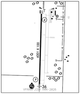
RWY 18–36: H6001X100 (CONC) S–30 HIRL 0.3% up N
RWY 18: REIL. PAPI(P4L)–GA 3.0° TCH 43′.
RWY 36: MALSR. PAPI(P4L)–GA 3.0° TCH 45′.
SERVICE: S6 FUEL 100LL, JET A LGT ACTVT MALSR Rwy 36; REIL Rwy 18; HIRL Rwy 18–36–CTAF. PAPI Rwy 18 and 36 on consly.
AIRPORT REMARKS: Attended continuously. Wildlife and ultralights on and invof arpt. Self svc fuel avbl 24 hrs for 100LL only. Rwy 18–36–60′ x 475′ asph safety area north of Rwy 18 thld. Asph twy sections not full strength. 450′ of north end of asphalt twy marked clsd with large yellow ′X′s. Acft maint on fld.
AIRPORT MANAGER: 417-850-1451
WEATHER DATA SOURCES: AWOS–3 118.275 (417) 476–2613.
COMMUNICATIONS: CTAF/UNICOM 123.075
®SPRINGFIELD APP/DEP CON 124.95
CLNC DEL 121.85
CLEARANCE DELIVERY PHONE: For CD ctc Springfield Apch at 417-868-56205619.
AIRSPACE: CLASS E.
RADIO AIDS TO NAVIGATION: NOTAM FILE COU.
NEOSHO (DH) DME 117.3 EOS Chan 120 N36°50.55′ W94°26.14′ 079° 20.6 NM to fld. 1200.
COMM/NAV/WEATHER REMARKS: UNICOM ireg mntd drng dalght hrs.