NATCHEZ
HARDY–ANDERS FLD/NATCHEZ–ADAMS CO (HEZ)(KHEZ) 6 NE UTC–6(–5DT) N31°36.82′ W91°17.84′ 272 B Class IV, ARFF Index A NOTAM FILE HEZ
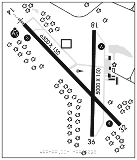
RWY 14–32: H6500X150 (ASPH–GRVD) S–50, D–78, 2D–172 PCR 45 F/B/X/T HIRL
RWY 14: MALSR. PAPI(P4R)–GA 3.0° TCH 55′.
RWY 32: PAPI(P4L)–GA 3.0° TCH 43′. Trees.
RWY 18–36: H5000X150 (ASPH) S–83, D–113, 2S–143, 2D–65 PCN 35 F/B/Y/T MIRL No Part 121/Part 380 Ops
RWY 18: VASI(V4L)–GA 3.0° TCH 30′.
RWY 36: Trees.
SERVICE: S2 FUEL 100LL, JET A LGT ACTVT MALSR Rwy 14; PAPI Rwy 14 and Rwy 32; VASI Rwy 18; MIRL Rwy 18–36–CTAF.
AIRPORT REMARKS: Attended 1200–0200Z‡. Deer on and invof rwys. Twy A & C1 not avbl for ACR use. Clsd to unsked ACR ops with more than 30 pax seats excp 48 hrs PPR call amgr. Gnd pwr unit avbl on field. Rwy 18–36 widespread cracking and uneven pavement.
AIRPORT MANAGER: 601-442-5171
WEATHER DATA SOURCES: AWOS–3PT 124.675 (601) 446–8022. LAWRS.
COMMUNICATIONS: CTAF/UNICOM 122.8
NATCHEZ RCO 122.6 (GREENWOOD RADIO)
®HOUSTON CENTER APP/DEP CON 120.975
RADIO AIDS TO NAVIGATION: NOTAM FILE HEZ.
NATCHEZ (L) DME 110.0 HEZ Chan 37 N31°37.09′ W91°17.98′ at fld. 280.
DME unusable:
Byd 25 NM blo 4,000′
Byd 9 NM blo 1,800′
NATCHEZ–ADAMS COUNTY NDB (MHW) 388 HAH N31°41.42′ W91°17.59′ 183° 4.6 NM to fld. 114/0E.
ILS 111.35 I–HEZ Rwy 14. Class IA. Glideslope unmonitored.