GLENCOE MUNI (GYL)(KGYL) 3 SE UTC–6(–5DT) N44°45.36′ W94°04.89′
993 B NOTAM FILE GYL
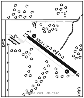
RWY 13–31: H3300X75 (ASPH) MIRL
RWY 13: REIL. PAPI(P4L)–GA 3.0° TCH 28′.
RWY 31: REIL. PAPI(P4L)–GA 3.0° TCH 28′.
SERVICE: FUEL 100LL LGT ACTVT or incr intst REIL Rwy 13 and 31; PAPI Rwy 13 and 31; MIRL Rwy 13–31–CTAF. MIRL Rwy 13–31 preset to low intst.
AIRPORT REMARKS: Unattended. Deer on and invof arpt. Ultralight act on and invof arpt. 100LL fuel avbl H24 via credit card.
AIRPORT MANAGER: 320-864-5586
WEATHER DATA SOURCES: AWOS–3 119.625 (320) 864–5830.
COMMUNICATIONS: CTAF/UNICOM 122.8
®MINNEAPOLIS APP/DEP CON 134.7
CLEARANCE DELIVERY PHONE: For CD ctc Minneapolis Apch at 612-726-9086.
RADIO AIDS TO NAVIGATION: NOTAM FILE PNM.
DARWIN (L) DME 109.0 DWN Chan 27 N45°05.25′ W94°27.23′ 141° 25.4 NM to fld. 1130.