GRAND ISLAND
CENTRAL NEBRASKA RGNL (GRI)(KGRI) P (ARNG) 3 NE UTC–6(–5DT) N40°58.05′ W98°18.58′ 1847 B ARFF Index–See Remarks NOTAM FILE GRI MON Airport
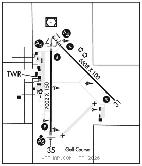
RWY 17–35: H7002X150 (CONC–GRVD) S–75, D–110, 2S–139, 2D–185 PCR 450 R/D/W/T HIRL
RWY 17: MALS. PAPI(P4L)–GA 3.0° TCH 38′. RVR–R
RWY 35: MALSR. PAPI(P4L)–GA 2.6° TCH 55′. RVR–T
RWY 13–31: H6608X100 (CONC) S–45, D–59 PCR 180 R/D/W/T MIRL
RWY 13: MALS. PAPI(P4L)–GA 3.0° TCH 35′.
RWY 31: REIL. PAPI(P4L)–GA 3.0° TCH 42′.
RUNWAY DECLARED DISTANCE INFORMATION
RWY 13: TORA–6608 TODA–6608 ASDA–6608 LDA–6608
RWY 17: TORA–7002 TODA–7002 ASDA–7002 LDA–7002
RWY 31: TORA–6608 TODA–6608 ASDA–6608 LDA–6608
RWY 35: TORA–7002 TODA–7002 ASDA–7002 LDA–7002
SERVICE: S4 FUEL 100LL, JET A OX1, 2 LGT ACTIVATE PAPI Rwy 31 and 35–CTAF. When twr clsd ACTIVATE MALS Rwy 13 and 17, MALSR Rwy 35; REIL Rwy 31; PAPI Rwy 13 and Rwy 17; MIRL Rwy 13–31, HIRL Rwy 17–35–CTAF. Rwy 35 PAPI restricted byd 6 degs right of cntrln. MILITARY–FUEL A+ (1200–0400Z‡. C308–382–5788; OT 1 hr PN rqr C308–382–5788, $50 fee.) (NC–100LL, A)
AIRPORTREMARKS:Attended continuously. Migratory waterfowl on and invof arpt. Class I, ARFF Index B. PPR 24 hrs for air carrier ops with more than 30 passenger seats call arpt manager 308–385–5170. Index B equipment provided. Index C level ARFF is avbl upon request. Air carrier ops over 9 passengers seats not authorized in excess of 15 minutes before or after scheduled arrival/departure times except with prior coordination with arpt manager. Twy D exit off Rwy 17–35 clsd to large acft due to inadequate turning radius.
AIRPORT MANAGER: 308-385-5170
WEATHER DATA SOURCES: ASOS (308) 314–0825 LAWRS.
COMMUNICATIONS: CTAF 118.2 ATIS 127.4 UNICOM 122.95
RCO 122.4 (COLUMBUS RADIO)
®MINNEAPOLIS CENTER APP/DEP CON 119.4
GRAND ISLAND TOWER 118.2 (1300–0200Z‡) GND CON 121.9 CLNC DEL 121.9 126.05 (when twr clsd)
AIRSPACE: CLASS D svc 1300–0200Z‡; other times CLASS E.
RADIO AIDS TO NAVIGATION: NOTAM FILE GRI.
GRAND ISLAND (VL) (L) VORW/DME 116.55 GRI Chan 112(Y) N40°59.04′ W98°18.89′ 160° 1.0 NM to fld. 18407E.
ILS 111.9 I–GRI Rwy 35. Class IC.