GRASS VALLEY
NEVADA CO (GOO)(KGOO) 3 E UTC–8(–7DT) N39°13.44′ W121°00.15′ 3158 B NOTAM FILE GOO
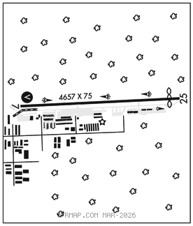
RWY 07–25: H4657X75 (ASPH) S–30 MIRL 1.9% up E
RWY 07: VASI(V4L)–GA 3.0° TCH 40′. Trees.
RWY 25: Thld dsplcd 304′. Pole.
SERVICE: S4 FUEL 100LL, JET A OX 1, 2 LGT ACTVT VASI Rwy 07; MIRL Rwy 07–25–CTAF.
AIRPORT REMARKS: Attended 1600–0400Z‡. Be alert May–Oct for Calfire Air Tanker ops flying ovhd pat for Rwy 07 (see AIM 5–4–27 for mnvr and phraseology). Expc tankers to dep Rwy 25 and land Rwy 07 regardless of wind cond. Rwy 07–25 slopes 1.9 pct downhill to the west. Rwy 07 tkofs not rcmdd due to rising trrn. Hels make straight–in apchs and deps.
AIRPORT MANAGER: 530-273-3374
WEATHER DATA SOURCES: AWOS–3 121.325 (530) 273–0029.
COMMUNICATIONS: CTAF/UNICOM 122.725
®NORCAL APP/DEP CON 125.4
CLEARANCE DELIVERY PHONE: For CD ctc NorCal Apch at 916-361-6874.
RADIO AIDS TO NAVIGATION: NOTAM FILE MYV.
MARYSVILLE (VL) (DL)VOR/DME 110.8 MYV Chan 45 N39°05.92′ W121°34.38′ 058° 27.7 NM to fld. 62/16E.
VOR unusable:
013°–089° byd 25 NM
015°–089° byd 25 NM
184°–194° byd 25 NM
199°–225° byd 25 NM
207°–217° byd 25 NM
260°–301° byd 58 NM
275°–295° byd 28 NM blo 6,000′
297°–300° byd 25 NM
DME unusable:
275°–295° byd 28 NM blo 6,000′