GAYLORD
GAYLORD RGNL (GLR)(KGLR) 1 SW UTC–5(–4DT) N45°00.78′ W84°42.21′ 1328 B NOTAM FILE GLR

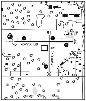
RWY 09–27: H6579X150 (ASPH) D–100, 2S–127 HIRL
RWY 09: MALSR. PAPI(P4L)–GA 3.0° TCH 38′. Tree.
RWY 27: REIL. PAPI(P4L)–GA 3.0° TCH 45′. Pole.
RWY 18–36: H4200X75 (ASPH) S–12.5 MIRL
RWY 18: REIL. PAPI(P4L)–GA 3.0° TCH 40′.
RWY 36: REIL. PAPI(P4L)–GA 3.0° TCH 40′.
SERVICE: S4 FUEL 100LL, JET A+ OX 3, 4 LGT Actvt MALSR Rwy 09; REIL Rwy 27, 18, & 36; PAPI Rwy 09, 27, 18, & 36; HIRL Rwy 09–27; MIRL Rwy 18–36–CTAF. Rwy 36 PAPI unusbl byd 8 degs left & 7 degs right of cntrln.
AIRPORT REMARKS: Attended May–Oct 1230–2300Z‡, Nov–Apr 1130–2200Z‡. For attendant aft hrs call amgr. Unatndd Thanksgiving, Christmas, & New Years Day. Deer and birds on and invof arpt. Admin bldg aces 5–3–2–1. Fuel subj aft hrs call–in fee. Ldg fee for turbine, jet, & twin–eng acft waived with mnm fuel purchase. Ovngt prkg fee. Mil trg act invof arpt assocd with R–4201A/B.
AIRPORT MANAGER: 989-732-4218
WEATHER DATA SOURCES: ASOS 118.375 (989) 732–1571.
COMMUNICATIONS: CTAF/UNICOM 122.8
RCO 122.4 (LANSING RADIO)
®MINNEAPOLIS CENTER APP/DEP CON 134.6
CLEARANCE DELIVERY PHONE: For CD if una to ctc on FSS freq, ctc Minneapolis ARTCC at 651-463-5588.
RADIO AIDS TO NAVIGATION: NOTAM FILE GLR.
(L) DME 109.2 GLR Chan 29 N45°00.75′ W84°42.26′ at fld. 1318.
DME unusable:
Byd 30 NM blo 3,500′
BANGU NDB (LOMW) 375 GL N45°00.88′ W84°48.48′ 097° 4.4 NM to fld. 1385/6W.
ILS 111.1 I–GLR Rwy 09. Class IE. LOM BANGU NDB. Unmonitored.