GREYBULL
SOUTH BIG HORN CO (GEY)(KGEY) 2 NW UTC–7(–6DT) N44°31.08′ W108°04.98′ 3942 B NOTAM FILE GEY
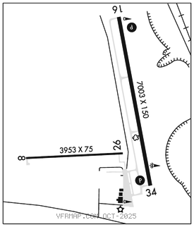
RWY 16–34: H7003X150 (ASPH) S–85, D–150, 2D–290 MIRL
RWY 16: REIL. PAPI(P4L)–GA 3.0° TCH 50′.
RWY 34: REIL. PAPI(P4L)–GA 3.0° TCH 50′.
RWY 08–26: H3953X75 (ASPH) S–12.5
SERVICE: S4 FUEL 100LL, JET A LGT Actvt MIRL Rwy 16–34; PAPI Rwy 16 and 34; REILS Rwy 16 and 34–CTAF.
AIRPORTREMARKS:Unattended. 100LL fuel avbl H24 via credit card. Jet–A fuel is full svc only. Fone ahd 307–680–4897 or text/call amgr. Antelope on and invofrwy. Terrain 1066′ abv arpt elevation 4–5 miles north and northeast of arpt. Pilot supplied ropes rqrd for tie downs.
AIRPORT MANAGER: 307-337-8159
WEATHER DATA SOURCES: ASOS 135.325 (307) 765–9406. Opr full–time 0700–0659Z‡.
COMMUNICATIONS: CTAF 122.9
®SALT LAKE CENTER APP/DEP CON 127.75
CLEARANCE DELIVERY PHONE: For CD ctc Salt Lake ARTCC at 801-320-2568.
RADIO AIDS TO NAVIGATION: NOTAM FILE WRL.
WORLAND (VL) (DH) VORW/DME 114.8 RLY Chan 95 N43°57.85′ W107°57.05′ 337° 33.7 NM to fld. 4204/13E.
VOR unusable:
070°–080° byd 40 NM blo 12,000′
070°–080° byd 56 NM
081°–230° byd 40 NM
305°–327° byd 40 NM
350°–069° byd 40 NM