FOSSTON MUNI/ANDERSON FLD (FSE)(KFSE) 1 NW UTC–6(–5DT) N47°35.57′ W95°46.41′
1279 B NOTAM FILE FSE
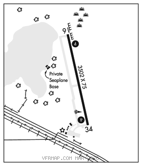
RWY 16–34: H3502X75 (ASPH) S–12.5 MIRL(NSTD) 0.4% up S
RWY 16: REIL. PAPI(P4L)–GA 2.8° TCH 25′.
RWY 34: REIL. PAPI(P4L)–GA 2.8° TCH 25′.
SERVICE: FUEL 100LL LGT ACTVT or incr intst REIL Rwy 16 and 34; PAPI Rwy 16 and 34; NSTD MIRL Rwy 16–34–CTAF. NSTD MIRL Rwy 16–34 preset low intst. NSTD MIRL due to Rwy 34 lgts not yellow last half rwy len.
AIRPORT REMARKS: Unattended. Fuel: 100LL avbl H24 self svc via credit card.
AIRPORT MANAGER: 218-435-1959
WEATHER DATA SOURCES: AWOS–3 118.35 (218) 435–6448.
COMMUNICATIONS: CTAF 122.9
®MINNEAPOLIS CENTER APP/DEP CON 134.75
GCO 121.725 (MINNEAPOLIS CENTER and FLIGHT SERVICES)
CLEARANCE DELIVERY PHONE: For CD if una via GCO ctc Minneapolis ARTCC at 651-463-5588.
RADIO AIDS TO NAVIGATION: NOTAM FILE TVF.
THIEF RIVER FALLS (VL) (L) VOR/DME 114.45 TVF Chan 91(Y) N48°04.16′ W96°11.19′ 142° 33.1 NM to fld. 1114/8E.
VOR unusable:
316°–330° blo 6,000′
316°–330° byd 9 NM
331°–342° blo 6,100′
331°–342° byd 13 NM
343°–346° blo 6,100′
343°–346° byd 57 NM
DME unusable:
316°–330° blo 6,000′
316°–330° byd 9 NM
331°–342° blo 6,100′
331°–342° byd 13 NM
343°–346° blo 6,100′
343°–346° byd 57 NM