FLORA MUNI (FOA)(KFOA) 2 E UTC–6(–5DT) N38°39.90′ W88°27.19′
473 B NOTAM FILE FOA
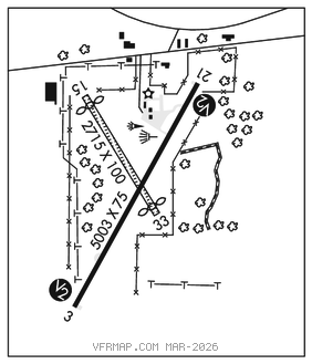
RWY 03–21: H5003X75 (ASPH) S–30, D–40 MIRL
RWY 03: PVASI(PSIL)–GA 3.0° TCH 23′. Tree.
RWY 21: REIL. PVASI(PSIL)–GA 3.0° TCH 25′. Tree.
RWY 15–33: 2715X100 (TURF) 0.3% up NW
RWY 15: Thld dsplcd 204′. Tree.
RWY 33: Thld dsplcd 174′. P–line.
SERVICE: FUEL 100LL, JET A LGT MIRL Rwy 03–21 preset on low ints; to increase ints and ACTIVATE REIL Rwy 21; PVASI Rwy 03 and Rwy 21, and twy lgts–CTAF.
AIRPORT REMARKS: Attended Mon–Fri 1400–2230Z‡. Fuel self svc with credit card. Rwy 15–33 soft when wet. Rwy 15–33 thlds and boundary outlined by white 1/2 tires. Day use only.
AIRPORT MANAGER: 618-662-2823
WEATHER DATA SOURCES: AWOS–3 120.175 (618) 662–8355.
COMMUNICATIONS: CTAF/UNICOM 122.7
®KANSAS CITY CENTER APP/DEP CON 127.7
CLEARANCE DELIVERY PHONE: For CD ctc Kansas City ARTCC at 913-254-8508.
RADIO AIDS TO NAVIGATION: NOTAM FILE STL.
BIBLE GROVE (L) (L) VORTAC 109.0 BIB Chan 27 N38°55.22′ W88°28.91′ 172° 15.4 NM to fld. 535/3E.
LOC/DME 108.55 I–RTT Chan 22(Y) Rwy 21. Unmonitored.