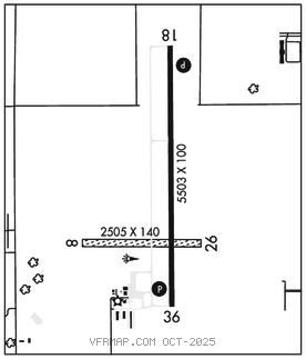
FAIRFIELD MUNI (FFL)(KFFL) 3 NW UTC–6(–5DT) N41°03.34′ W91°58.85′
801 B TPA–1802(1001) NOTAM FILE FFL

RWY 18–36: H5503X100 (CONC) S–30, D–45 PCN 16 R/C/W/T MIRL
RWY 18: REIL. PAPI(P4L)–GA 3.0° TCH 40′.
RWY 36: REIL. PAPI(P4L)–GA 3.0° TCH 40′. Road.
RWY 08–26: 2505X140 (TURF)
RWY 08: Fence.
RWY 26: Fence.
SERVICE: S4 FUEL 100LL, JET A LGT ACTIVATE MIRL Rwy 18–36, PAPI and REIL Rwys 18 and 36–CTAF.
AIRPORT REMARKS: Attended Mon–Fri 1330–2230Z‡, Sat–Sun on call. Arpt unattended all major holidays. Rwy 08–26 CLOSED Nov–Mar. Parachute Jumping. Birds on and invof arpt. Rwy 36 is calm wind rwy. Rwy 08 and Rwy 26 thlds and edges marked with yellow cones, thld cones have red/green reflector tape and edge cones have white.
AIRPORT MANAGER: 641-472-3166
WEATHER DATA SOURCES: AWOS–3 132.025 (641) 472–4548.
COMMUNICATIONS: CTAF/UNICOM 122.7
®CHICAGO CENTER APP/DEP CON 118.15
CLEARANCEDELIVERY PHONE: For CD ctc Chicago ARTCC at 630-906-8921.
RADIO AIDS TO NAVIGATION: NOTAM FILE OTM.
OTTUMWA (L) DME 116.35 OTM Chan 110(Y) N41°01.75′ W92°19.55′ 084° 15.7 NM to fld. 817.