KILL DEVIL HILLS
FIRST FLIGHT (FFA)(KFFA) 1 W UTC–5(–4DT) N36°01.06′ W75°40.30′ 12 NOTAM FILE FFA
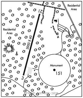
RWY 03–21: H3000X60 (ASPH) S–10
RWY 03: Trees.
RWY 21: Trees. Rgt tfc.
AIRPORT REMARKS: Unattended. Arpt clsd 30 mins after SS until 30 mins before SR. Deer and birds on and invof arpt. Hang gliding & powered hang gliding to 4000 ft invof arpt from SR–SS year round. 100 ft+ mkd transmission plines w/ hazard balls, lights 1300 ft fm thr in apch area Rwy 21; 300 ft twr and tank 1/2 mi N of Rwy 21 thr. Holdlines Rwy 21 are 115 ft fm cntrln. Rwy 21 has 10 ft deep ditch 400 ft fm thr. Max of 24 hrs prkg pmtd. No more than two ovngt stays per month. Restroom facilities on site; key code access to pilot lounge.
AIRPORT MANAGER: 252-475-9000
WEATHER DATA SOURCES: AWOS–3 118.075 (252) 449–0698.
COMMUNICATIONS: CTAF 122.9
®CHERRY POINT APP/DEP CON 124.725
CLEARANCE DELIVERY PHONE: For CD ctc Washington ARTCC at 703-771-3587.
RADIO AIDS TO NAVIGATION: NOTAM FILE MQI.
WRIGHT BROTHERS (T) (T) VORW/DME 111.6 RBX Chan 53 N35°55.23′ W75°41.82′ 020° 5.9 NM to fld. 108W. VOR/DME unmonitored 2300–1300Z‡.
VOR unusable:
281°–318° blo 8,000′
319 blo 4,000′
320°–280°