FARIBAULT MUNI–LIZ WALL STROHFUS FLD (FBL)(KFBL) 3 NW UTC–6(–5DT) N44°19.74′
W93°18.78′ 1060 B NOTAM FILE FBL
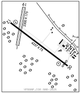
RWY 12–30: H4257X75 (ASPH) S–16, D–22 MIRL 0.3% up NW
RWY 12: REIL. PAPI(P4L)–GA 3.0° TCH 40′. Tree.
RWY 30: REIL. PAPI(P4L)–GA 3.0° TCH 40′. Thld dsplcd 230′. Road.
RWY 01–19: 2300X175 (TURF)
RWY 01: Trees.
SERVICE: S4 FUEL 100LL, JET A OX 4 LGT MIRL Rwy 12–30 preset to low, to incr ints and ACTIVATE REIL Rwy 12 and Rwy 30–CTAF. Rwy 12 PAPI ops continuously. Rwy 30 PAPI opr continuously.
AIRPORT REMARKS: Attended May–Sep 1400–0000Z‡, Oct–Apr Mon–Fri 1400–0000Z‡, Oct–Apr Sat 1600–2100Z‡, Oct–Apr Sun unattended. For svc after hrs call 507–838–7152. Self svc fuel with credit card. Rwy 01–19 not plowed winter months. Open for skiplanes. When landing on Rwy 12, be alert for turbulence and possible windshear when winds are out of the south. Ultralights and gliders use twy and extended twy parallel to Rwy 12–30. Ultralights and gliders using twy fly pattern on NE side of Rwy 12–30. Rwy 01–19 marked with yellow cones.
AIRPORT MANAGER: 507-332-0140
WEATHER DATA SOURCES: AWOS–3 120.2 (507) 332–2505.
COMMUNICATIONS: CTAF/UNICOM 122.8
®MINNEAPOLIS APP/DEP CON 134.7
GCO 121.725 (MINNEAPOLIS CLNC and FLIGHT SERVICES)
CLEARANCE DELIVERY PHONE: For CD ctc Minneapolis Apch at 612-726-9086.
RADIO AIDS TO NAVIGATION: NOTAM FILE PNM.
HALFWAY (T) (T) VORW/DME 111.2 FOW Chan 49 N44°12.27′ W93°22.23′ 016° 7.9 NM to fld. 1099/2E. VOR/DME unmonitored.