FAYETTEVILLE
FAYETTEVILLE RGNL/GRANNIS FLD (FAY)(KFAY) 3 S UTC–5(–4DT) N34°59.47′ W78°52.82′ 189 B Class I, ARFF Index B NOTAM FILE FAY
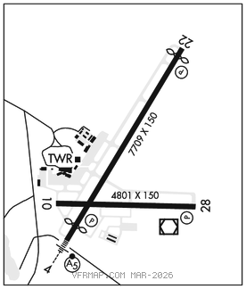
RWY 04–22: H7709X150 (ASPH–GRVD) S–109, D–178, 2S–175, 2D–321 PCR 430 F/A/X/T HIRL 0.3% up SW
RWY 04: MALSR. PAPI(P4R)–GA 3.13° TCH 47′. RVR–T Thld dsplcd 598′.
RWY 22: REIL. PAPI(P4L)–GA 3.0° TCH 48′. RVR–R Thld dsplcd 303′.
RWY 10–28: H4801X150 (ASPH) S–53, D–75 PCN 17 F/A/X/T MIRL
RWY 10: REIL. Trees.
RWY 28: REIL. PAPI(P4L)–GA 3.0° TCH 36′. Trees.
RUNWAY DECLARED DISTANCE INFORMATION
RWY 04: TORA–7709 TODA–7709 ASDA–7006 LDA–6408
RWY 22: TORA–7709 TODA–7709 ASDA–6711 LDA–6408
SERVICE: S4 FUEL 100LL, JET A
AIRPORT REMARKS: Attended 1100–0500Z‡. CLOSED to all mil acft over 17,000 lbs for air carrier ramp ops exc 24 hr PPR. Call arpt mgr 910–433–1160, Mon–Fri. Major power plant repairs avbl for piston engines only.
AIRPORT MANAGER: 910-433-1625
WEATHER DATA SOURCES: ASOS 121.25 (910) 484–1546. LAWRS. LLWAS.
COMMUNICATIONS: ATIS 121.25 UNICOM 122.95 ® APP/DEP CON 125.175 321°–060° 127.8 231°–320° 133.0 61°–230°
TOWER 118.3 GND CON 121.7
AIRSPACE: CLASS C svc ctc APP CON.
RADIO AIDS TO NAVIGATION: NOTAM FILE FAY.
(L) (L) VORW/DME 114.85 FAY Chan 95(Y) N34°59.13′ W78°52.50′ at fld. 187/4W.
VOR unusable:
058°–068° blo 4,000′
090°–100°
DME unusable:
090°–100°
ILS/DME 110.5 I–GRA Chan 42 Rwy 04. Class IB. Glideslope unusable byd 3° right of course.