MONROE
CHARLOTTE/MONROE EXEC (EQY)(KEQY) 5 NW UTC–5(–4DT) N35°01.04′ W80°37.32′ 683 B LRA NOTAM FILE EQY
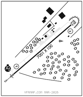
RWY 05–23: H7001X100 (ASPH) S–35, D–68.5 HIRL 0.3% up SW
RWY 05: MALSR. PAPI(P4L)–GA 3.0° TCH 46′. Trees.
RWY 23: REIL. PAPI(P4L)–GA 3.0° TCH 40′. Trees.
SERVICE: S4 FUEL 100LL, JET A1+ OX 3, 4 LGT ACTVT MALSR Rwy 05; REIL Rwy 23; HIRL Rwy 05–23–CTAF. All lights oper dusk–0500Z‡. After 0500Z‡, ACTVT–122.7. PAPI Rwy 05 & 23 oper consly.
AIRPORTREMARKS: Attended 1200–0000Z‡. Deer, wildlife, and birds on and invof arpt. Fuel 24 hr credit card svc avbl. Right side of Twy A at Rwy 23 has steep shoulder drop–off btn rwy and Twy A.
AIRPORT MANAGER: 704-282-4730
WEATHER DATA SOURCES: ASOS 135.775 (704) 283–5185.
COMMUNICATIONS: CTAF/UNICOM 122.7
®CHARLOTTE APP/DEP CON 120.05
CLNC DEL 132.55
CLEARANCE DELIVERY PHONE: For CD ctc Charlotte Apch at 704-359-0241.
RADIO AIDS TO NAVIGATION: NOTAM FILE CLT.
(L) (L) VORW/DME 115.0 CLT Chan 97 N35°11.42′ W80°57.11′ 127° 19.3 NM to fld. 732/5W.
DME portion unusable:
015°–050° byd 25 NM blo 3,000′
050°–100° byd 25 NM blo 2,500′
185°–202° byd 15 NM
203°–220°
270°–350° byd 20 NM blo 5,000′
VOR/DME controlled by Charlotte ATCT
VOR unusable:
203°–220°
ILS/DME 109.75 I–EQY Chan 34(Y) Rwy 05. Class IA. LOC unmonitored 2200–1300Z‡. LOC unusable byd 30° left of course.
COMM/NAV/WEATHER REMARKS: Arpt phone number 704–282–4730.