SHELBY–CLEVELAND CO RGNL (EHO)(KEHO) 3 SW UTC–5(–4DT) N35°15.34′ W81°36.05′
847 B NOTAM FILE EHO
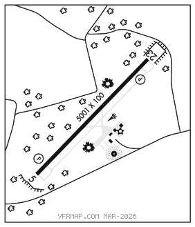
RWY 05–23: H5001X100 (ASPH) S–21 MIRL
RWY 05: PAPI(P2L)–GA 3.0° TCH 41′. Trees.
RWY 23: PAPI(P2L)–GA 3.0° TCH 28′. Trees.
SERVICE: S4 FUEL 100LL, JET A1+ LGT Dusk–0400Z‡. After 0400Z‡, ACTVT MIRL Rwy 05–23–CTAF. PAPI Rwy 05 and 23 oper consly.
AIRPORT REMARKS: Attended Mon–Fri 1300–2200Z‡, Sat 1500–2000Z‡, Sun 1800–2100Z‡. 100LL fuel 24 hr credit card svc avbl. For svc after hrs call 704–284–3321. Rwy 05 has 45′ dropoff 100′ from thld. Rwy 23 has 35′ dropoff 600′ from thld. Refer to Charlotte sectional chart for towers off both runway ends.
AIRPORT MANAGER: 704-487-1161
WEATHER DATA SOURCES: AWOS–3 118.425 (704) 487–0100.
COMMUNICATIONS: CTAF/UNICOM 122.8
®CHARLOTTE APP/DEP CON 120.05
CLEARANCE DELIVERY PHONE: For CD ctc Charlotte Apch at 704-359-0241.
RADIO AIDS TO NAVIGATION: NOTAM FILE SPA.
SPARTANBURG (H) (H) VORTAC 115.7 SPA Chan 104 N35°02.02′ W81°55.62′ 052° 20.9 NM to fld. 935/2W.
VOR unusable:
270°–359° byd 7 NM blo 3,000′
Byd 28 NM blo 7,000′
Byd 9 NM blo 6,000′
FIRST RIVER NDB (MHW) 417 SLP N35°15.16′ W81°35.93′ at fld. 8506W. NOTAM FILE RDU.