ELIZABETH CITY CG AIR STATION/RGNL (ECG)(KECG) P (CG) 3 SE UTC–5(–4DT) N36°15.63′
W76°10.47′ 11 B TPA–See Remarks NOTAM FILE ECG
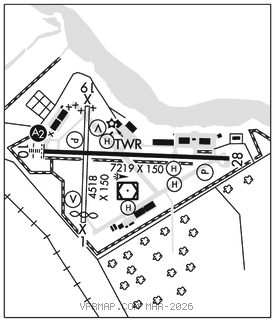
RWY 10–28: H7219X150 (CONC) S–100, D–200, 2S–175, 2D–400 PCN 40 R/B/W/T HIRL
RWY 10: SALS. REIL. PAPI(P2L)–GA 3.0° TCH 49′. Road. Rgt tfc.
RWY 28: REIL. PAPI(P2L)–GA 3.0° TCH 50′. Trees.
RWY 01–19: H4518X150 (ASPH–CONC) S–20 MIRL
RWY 01: VASI(V4L)–GA 2.75° TCH 25′. Thld dsplcd 299′. Road. Rgt tfc.
RWY 19: VASI(V4L)–GA 2.75° TCH 30′. Rgt tfc.
SERVICE: S4 FUEL 100LL, JET A1+ LGT ACTVT SALS Rwy 10; HIRL Rwy 10–28–CTAF. When ATCT clsd, REILS Rwy 10 and 28; PAPI Rwy 10 & 28 opr consly. VASI Rwy 01 and 19; MIRL Rwy 01–19 OTS indefly. MILITARY– FLUID SP LHOX OIL 0–133–156 TRAN ALERT No tran maint, ltd svc. Tran air carrier must remain with acft to provide tech directions/assistance in svcg. PPR for parking and svcs on CG Ramp and Aviation Logistic Center (ALC) ramp.
NOISE: Noise abatement procedures in effect, call amgr 719–505–6367.
AIRPORT REMARKS: Attended Mon–Fri 1300–0200Z‡, Sat–Sun 1300–2200Z‡. Rwy 01–19 CLOSED indefly. Rwy 01–19 pavement is failed, nmrs ruts, heaves, structural integrity unkn. FOD potential. Sfc mrks obsc. Not auzd for use. Rwy 01 end mkd with X closed. Twr attended 1100–0200Z‡. Civ ramp attended Mon–Fri 1300–0200Z‡, Sat–Sun 1300–2200Z‡. For general aviation attendance after hrs and holidays call 252–562–2472 or ctc nos posted on trml door. 100LL fuel 24 hr credit card svc avbl. Intermittent tethered bln opns 3 NM SE; dalgt hrs at 5000 ft. Rwy and twy sfc cond not mnt wkends or Mon–Fri btn 2000Z–1200Z. PPR if ACN exceeds publ PCN. Ctc CG afld mgr C719–505–6367 to obtain apvl. Rwy 01–19 & Twy K west of the civil ramp clsd to all opns. Vertical tkf and ldg only for copters over 12,500 lbs. Rwy 01–19 numerous ruts, heaves, structural integrity unknown. Foreign object damage potential. Sfc marks obscured, not authorized for mil use. Acft with tail heights to 50 ft parked on apron first 2000 ft fm Rwy 28 right side 250 ft fm rwy cntrln. TPA–Rotary Wing 1000′ AGL/1011′ MSL, Fixed Wing 1500′ AGL/1511′ MSL. All DoD turbojet acft must obtain prior permission from air station ops prior to req arpt familiarization apchs. All DoD turbojet acft full stop only, practice apchs and VFR touch–and–gos prohibited. Coast Guard complex has numerous bldgs wi the bldg rstrn lines. Seasonal low flying AG acft based in the lcl area. No line–of–sight between rwy ends. Search and Rescue may rqr 24 hr twr staff 0200–1300Z‡, transmit intentions in the blind on 120.5. Facilities and ramps north of Rwy 10–28 rstrd to offl CG bus only. All acft destined for CG Air Station ctc Elizabeth City Air on 345.0, 10 min prior to ldg. All acft destined for CG ALC ctc ALC Duty Officer (C252–333–5389) NLT 24hrs for PPR and ctc Flt Ops 123.1 prior to landing. Rwy 10–28 increased potential for hydroplaning due to rubber deposits, cntrln obstruction. Rwy 07 and 25 markings faded.
MILITARY REMARKS: See FLIP AP/1 supplementary Arpt Info. CG ramp attended 24 hrs, ctc 252–335–6333. CG Aviation Logistic Center ramp attended 1200–2000Z‡. DLA mil fueling contract svc avbl on general aviation ramp, US Govt aircard accepted, no delay for fuel. MISC Alfd mowing season Apr–Oct. Expect increased bird activity in vicinity of mowers opr on afld. Portions of ALC prk ramp not vis from twr. Non–frangible high voltage boxes located on S edge of ALC ramp.
AIRPORT MANAGER: 719-505-6367
WEATHER DATA SOURCES: ASOS 124.375 (252) 338–4750.
COMMUNICATIONS: CTAF 120.5 UNICOM 122.95
RCO 122.2 (RALEIGH RADIO)
®NORFOLK APP/DEP CON 119.55
TOWER 120.5 (1200–0300Z‡.) GND CON 121.9
CLEARANCE DELIVERY PHONE: For CD when ATCT clsd, ctc Norfolk Apch at 757-464-0757.
AIRSPACE: CLASS D svc 1200–0300Z‡; other times CLASS E.
RADIO AIDS TO NAVIGATION: NOTAM FILE ECG.
(VL) (DH) VORW/DME 115.75 ECG Chan 104(Y) N36°15.45′ W76°10.54′ at fld. 7/7W.
DME unusable:
250°–280° byd 30 NM blo 8,000′
VOR unusable:
045°–244° byd 40 NM
245°–255° byd 40 NM blo 7,000′
245°–255° byd 60 NM
256°–025° byd 40 NM
WOODVILLE NDB (MHW) 254 LLW N36°15.78′ W76°17.88′ 101° 6.0 NM to fld. 18/10W.
ILS/DME 111.35 I–EPR Chan 50(Y) Rwy 10. Class IE. Autopilot cpd apch NA blw 905′ MSL.
COMM/NAV/WEATHER REMARKS: 24 hr search and rescue acft ops may rqr twr to be staffed 0300–1200Z‡, transmit intentions in the blind on 120.5. • • • • • • • • • • • • • • • • • •
HELIPAD H1: H60X55 (ASPH)
HELIPAD H1: Acft.
HELIPAD H2: H50X50 (ASPH)
HELIPAD H2: Acft.
HELIPAD H3: H50X50 (ASPH)
HELIPAD H4: H100X100 (CONC) PERIMETER LGTS