KEARNEY RGNL (EAR)(KEAR) 4 NE UTC–6(–5DT) N40°43.62′ W99°00.41′
2132 B ARFF Index–See Remarks NOTAM FILE EAR
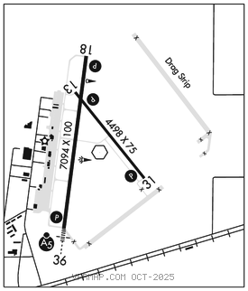
RWY 18–36: H7094X100 (CONC) S–46, D–62, 2S–93 PCN 15 R/B/W/T HIRL
RWY 18: REIL. PAPI(P4L)–GA 3.0° TCH 46′. Bldg.
RWY 36: MALSR. PAPI(P4L)–GA 3.0° TCH 43′.
RWY 13–31: H4498X75 (CONC) S–30, D–38 PCN 9 R/C/X/T MIRL
RWY 13: PAPI(P2L)–GA 3.0° TCH 43′.
RWY 31: PAPI(P2L)–GA 3.0° TCH 44′.
RUNWAY DECLARED DISTANCE INFORMATION
RWY 13: TORA–4498 TODA–4498 ASDA–4498 LDA–4498
RWY 18: TORA–7094 TODA–7094 ASDA–7094 LDA–7094
RWY 31: TORA–4498 TODA–4498 ASDA–4498 LDA–4498
RWY 36: TORA–7094 TODA–7094 ASDA–7094 LDA–7094
SERVICE: S4 FUEL 100LL, JET A LGT HIRL Rwy 18–36 preset on low ints, to increase ints and ACTIVATE REIL Rwy 18; MALSR Rwy 36; PAPI Rwy 13, Rwy 18, Rwy 31 and Rwy 36; MIRL Rwy 13–31–CTAF.
AIRPORT REMARKS: Attended 1200–0200Z‡. Class I, ARFF Index A. ARFF Index B equipment provided. PPR 48 hrs for air carrier OPS with more than 30 passenger seats. Call arpt manager 308–234–2318 or 308–440–6069. Air carrier ops are not authorized in excess of 15 minutes before or after scheduled arrival/departure times without prior coordination with airport manager and confirmation that ARFF is avbl prior to landing or takeoff. Be alert when taxiing on apron due to several clsd areas.
AIRPORT MANAGER: 308-234-2318
WEATHER DATA SOURCES: AWOS–3PT 123.875 (308) 237–5608.
COMMUNICATIONS: CTAF/UNICOM 123.0
RCO 122.6 (COLUMBUS RADIO)
®MINNEAPOLIS CENTER APP/DEP CON 119.4
CLEARANCE DELIVERY PHONE: For CD if una to ctc on FSS freq, ctc Minneapolis ARTCC at 651-463-5588.
AIRSPACE: CLASS E.
RADIO AIDS TO NAVIGATION: NOTAM FILE EAR.
(L) VORW 111.2 EAR N40°43.54′ W99°00.31′ at fld. 2127/5E.
HASTINGS (L) DME 108.8 HSI Chan 25 N40°36.27′ W98°25.78′ 286° 27.4 NM to fld. 1957. NOTAM FILE HSI.
ILS/DME 110.9 I–EAR Chan 46 Rwy 36. Class IE.