MADISON
LAC QUI PARLE CO (DXX)(KDXX) 2 SE UTC–6(–5DT) N44°59.19′ W96°10.67′ 1083 B NOTAM FILE DXX
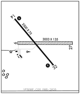
RWY 14–32: H3300X75 (ASPH) MIRL
RWY 14: REIL. PAPI(P4L)–GA 3.0° TCH 23′.
RWY 32: REIL. PAPI(P4L)–GA 3.0° TCH 23′.
RWY 09–27: 3003X135 (TURF)
SERVICE: FUEL 100LL LGT ACTVT or incr intst REIL Rwy 14 and 32; PAPI Rwy 14 and 32; MIRL Rwy 14–32–CTAF. MIRL Rwy 14–32 preset low intst SS–SR.
AIRPORTREMARKS:Unattended. Fuel: 100LL: avbl H24 via credit card. Rwy 09–27 not plowed winter months. Rwy 09–27 marked with yellow cones.
AIRPORT MANAGER: 320-333-9300
WEATHER DATA SOURCES: AWOS–3 118.975 (320) 598–3863.
COMMUNICATIONS: CTAF/UNICOM 122.8
MADISON RCO 122.3 (PRINCETON RADIO)
MINNEAPOLIS CENTER APP/DEP CON 128.5
CLEARANCEDELIVERY PHONE: For CD if una to ctc on FSS freq, ctc Minneapolis ARTCC at 651-463-5588.
RADIO AIDS TO NAVIGATION: NOTAM FILE MVE.
MONTEVIDEO (T) (T) VORW/DME 111.6 MVE Chan 53 N44°58.36′ W95°42.73′ 268° 19.8 NM to fld. 1037/5E. TVOR/DME unmonitored.
VOR unusable:
080°–150°
185°–195°