DAVID WAYNE HOOKS MEML (DWH)(KDWH) 17 NW UTC–6(–5DT) N30°03.71′
W95°33.17′ 152 B NOTAM FILE DWH
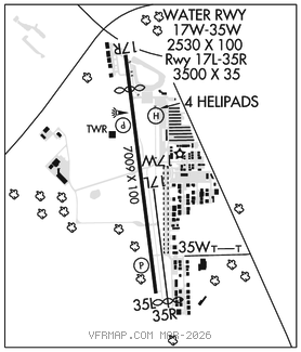
RWY 17R–35L: H7009X100 (ASPH) S–30, D–85 HIRL
RWY 17R: REIL. PAPI(P4R)–GA 3.0° TCH 52′. Thld dsplcd 1007′. Road.
RWY 35L: REIL. PAPI(P4L)–GA 3.0° TCH 41′. Trees.
RWY 17L–35R: H3500X35 (ASPH) S–12.5
RWY 35R: Thld dsplcd 208′. Antenna. Rgt tfc.
RUNWAY DECLARED DISTANCE INFORMATION
RWY 17R:TORA–7009 TODA–7009 ASDA–7009 LDA–6002
RWY 35L:TORA–6700 TODA–6700 ASDA–6700 LDA–6700
SERVICE: S4 FUEL 100LL, JET A, A1+ OX 2 LGT When ATCT clsd ACTVT REIL Rwys 17R and 35L; HIRL Rwy 17R–35L–CTAF. 17R REIL lctd at dsplcd thld.
NOISE: Noise sensitive area SW of arpt. All mil acft departing Rwy 17R climb rwy hdg 650 ft MSL prior to turns or rejoin.
AIRPORT REMARKS: Attended continuously. Rpd rfl avbl hel durg FBO hrs, PPR 24 hrs. Ctc opns mgr 832–953–8572 or freq 122.95 prior to lndg. Birds and deer on and invof arpt. Hel practice area west of ATCT at or blo 600 ft. Twys A and B clsd east of Rwy 17R indef. Acft 25000 lbs and ovr are rstrd to Twys C, P, E (btn Twys P and G), Twy G (north of Twy E), ramps A and C and the tomball jet cntr ramp. All other twys rstrd to acft below 25000 lbs. Twys D and K rstrd to acft 12500 lbs and blw. Twy K rstrd to piston acft only. Twys unlgtd. After SS large acft use Twy P btn Twys E and C. Intersection where Twys Papa, Echo, Juliette and Kilo meet is referred to as the triangle. Four hel prkg spots lctd east of Twy K.
AIRPORT MANAGER: 281-376-5436
WEATHER DATA SOURCES: ASOS 128.375 (281) 251–7853.
COMMUNICATIONS: CTAF 118.4 ATIS 128.375 UNICOM 122.95
®HOUSTON APP/DEP CON 119.7
HOOKS TOWER 118.4 (West) 127.4 (East) (1300–0400Z‡) GND CON 121.8 CLNC DEL 119.45
CLEARANCEDELIVERY PHONE: For CD when ATCT clsd, ctc Houston Apch on CD freq or call 281-443-5844. For IFR cancellation when ATCT clsd, call 281-443-5888.
AIRSPACE: CLASS D svc 1300–0400Z‡; other times CLASS G.
RADIO AIDS TO NAVIGATION: NOTAM FILE IAH.
HUMBLE (H) (H) VORTACW 116.6 IAH Chan 113 N29°57.42′ W95°20.74′ 295° 12.5 NM to fld. 81/5E. VORTAC monitored by ATCT
VOR portion unusable:
060°–070° byd 35 NM
175°–185° byd 20 NM blo 3,000′
Byd 30 NM blo 2,000′
DME unusable:
015°–090° byd 30 NM blo 2,000′
130°–320° byd 30 NM blo 2,000′
175°–185° byd 20 NM blo 3,000′
230°–250°
TACAN AZIMUTH unusable:
040°–055° blo 5,000′
150°–320° blo 4,500′
150°–320° byd 10 NM
LOC/DME 110.5 I–HEW Chan 42 Rwy 17R. DME unmonitored. • • • • • • • • • • • • • • • • • •
WATERWAY 17W–35W: 2530X100 (WATER)
WATERWAY 17W: Berm.
WATERWAY 35W: Berm. Rgt tfc.
SEAPLANE REMARKS: Rwy 17W marked by buoy. Rwy 35W marked by buoy. • • • • • • • • • • • • • • • • • •
HELIPAD H1: H50X50 (ASPH)
HELIPAD H2: H50X50 (ASPH)
HELIPAD H3: H50X50 (ASPH)
HELIPAD H4: H50X50 (ASPH)