DAVENPORT MUNI (DVN)(KDVN) P (ARNG) 5 N UTC–6(–5DT) N41°36.62′ W90°35.30′
751 B NOTAM FILE DVN
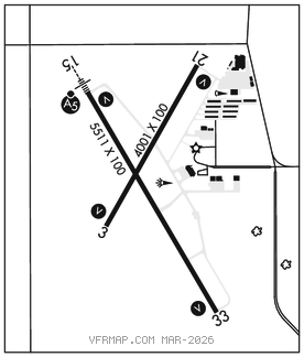
RWY 15–33: H5511X100 (CONC–GRVD) S–68, D–93, 2D–122 PCN 29 R/B/W/U HIRL
RWY 15: MALSR. VASI(V4L)–GA 3.0° TCH 56′. Road.
RWY 33: REIL. VASI(V4L)–GA 3.0° TCH 48′.
RWY 03–21: H4001X100 (CONC–GRVD) S–68, D–93, 2D–122 PCN 29 R/B/W/U MIRL
RWY 03: REIL. VASI(V4L)–GA 3.0° TCH 43′.
RWY 21: REIL. VASI(V4L)–GA 3.0° TCH 45′. Road.
SERVICE: S4 FUEL 100LL, JET A LGT Dusk–Dawn. ACTIVATE MIRL Rwy 03–21 and HIRL Rwy 15–33, VASI Rwy 03 and Rwy 21 and Rwys 15 and Rwy 33, MALSR Rwy 15 and REIL Rwy 03 and Rwy 21 and Rwy 33–CTAF. MILITARY–FUEL J8–PPR, DSN 793–4733. (Mil) (NC–100LL – self svc SE apron off of Twy C; A)
AIRPORT REMARKS: Attended 1230Z‡–dusk. Wildlife invof. For svc after hrs call 563–391–5650. Jet A and 100LL full svc avbl on main ramp in front of terminal bldg. 100LL self svc fuel avbl on east end of Twy C. Extensive heavy military helicopter (Chinook) training on and invof arpt, possible extreme turbulence from rotors. Helicopter ops on CTAF operating parallel to rwys from grass areas. Two way radio communications required for all acft conducting multiple ops. Rwy 15 designated calm wind rwy. PAEW ANG ramp limited parking 48 hr PPR.
AIRPORT MANAGER: 563-326-7783
WEATHER DATA SOURCES: ASOS 120.175 (563) 388–2154.
COMMUNICATIONS: CTAF/UNICOM 123.0
®QUAD CITY APP/DEP CON 125.95 (1130–0430Z‡)
®CHICAGO CENTER APP/DEP CON 118.75 (0430–1130Z‡)
CLNC DEL 118.35
CLEARANCE DELIVERY PHONE: For CD ctc Chicago ARTCC at 630-906-8921.
AIRSPACE: CLASS E svc 1130–0430Z‡; other times CLASS G.
VOR TEST FACILITY (VOT) 111.8
RADIO AIDS TO NAVIGATION: NOTAM FILE FOD.
(L) (L) VORTACW 113.8 CVA Chan 85 N41°42.51′ W90°29.00′ 215° 7.6 NM to fld. 767/4E.
ILS/DME 109.1 I–DVN Chan 28 Rwy 15. Class IT. Unmonitored.