DETROIT LAKES/WETHING FLD (DTL)(KDTL) 2 W UTC–6(–5DT) N46°49.38′ W95°52.97′
1396 B NOTAM FILE DTL
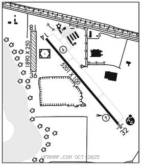
RWY 14–32: H5201X100 (ASPH) S–23, D–42 HIRL
RWY 14: REIL. PAPI(P4L)–GA 3.0° TCH 43′.
RWY 32: MALSF. PAPI(P4L)–GA 3.0° TCH 42′.
RWY 18–36: 1890X250 (TURF)
RWY 36: Trees.
SERVICE: S4 FUEL 100LL, JET A LGT Actvt MALSF Rwy 32; REIL Rwy 14; HIRL Rwy 14–32–CTAF. PAPI Rwy 14 and 32 opr consly.
AIRPORT REMARKS: Attended Mon–Fri 1400–2300Z‡. 100LL fuel avbl H24 self svc. For Jet A svc aft hrs call AMGR. Rwy 18–36 not plowed winter months. Rwy 18–36 marked with cones.
AIRPORT MANAGER: 218-841-8233
WEATHER DATA SOURCES: AWOS–3PT 119.075 (218) 847–8626.
COMMUNICATIONS: CTAF/UNICOM 122.8
RCO 122.5 (PRINCETON RADIO)
®MINNEAPOLIS CENTER APP/DEP CON 126.1
CLEARANCE DELIVERY PHONE: For CD if una to ctc on FSS freq, ctc Minneapolis ARTCC at 651-463-5588.
RADIO AIDS TO NAVIGATION: NOTAM FILE DTL.
(T) (T) VORW/DME 111.2 DTL Chan 49 N46°49.53′ W95°53.24′ at fld. 1385/2E. VOR/DME unmonitored.