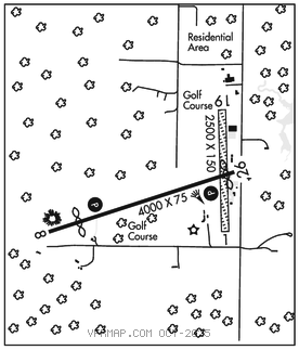
DRUMMOND ISLAND
DRUMMOND ISLAND (DRM)(KDRM) 1 SW UTC–5(–4DT) N46°00.56′ W83°44.64′ 668 B NOTAM FILE DRM

RWY 08–26: H4000X75 (ASPH) MIRL
RWY 08: PAPI(P2L)–GA 3.0° TCH 35′. Thld dsplcd 650′. Trees.
RWY 26: PAPI(P2L)–GA 3.0° TCH 25′. Thld dsplcd 170′. Road.
RWY 01–19: H2500X150 (ASPH–TURF)
RWY 01: Trees.
RWY 19: Trees.
SERVICE: FUEL 100LL, MOGAS LGT ACTIVATE PAPI Rwy 08 and 26 and MIRL Rwy 08–26–CTAF.
AIRPORTREMARKS:Attended Mon–Sat 1300–2200Z‡. Birds and deer invof arpt. Golf carts and pedestrians xng Rwy 08–26 due to golf crs on both sides. D22 SPB lctd 1.5 NM North. Rwy 01–19 center 20′ of rwy fm int Rwy 08–26 north to the hngr line is asph; rmndr of rwy turf. Rwy 01–19 marked with 3′ yellow cones.
AIRPORT MANAGER: 906-493-5411
WEATHER DATA SOURCES: AWOS–3 118.325 (906) 493–6410.
COMMUNICATIONS: CTAF/UNICOM 122.8
®TORONTO CENTER APP/DEP CON 132.65
CLEARANCE DELIVERY PHONE: For CD ctc Minneapolis ARTCC at 651-463-5588.
RADIO AIDS TO NAVIGATION: NOTAM FILE CIU.
SAULT STE MARIE (VH) (DH) VOR/DME 112.2 SSM Chan 59 N46°24.73′ W84°18.89′ 139° 33.9 NM to fld. 687/4W.
VOR unusable:
007°–034° byd 40 NM
052°–095° byd 40 NM
085°–105° byd 10 NM blo 5,000′
085°–105° byd 20 NM blo 8,000′
124°–134° byd 40 NM
157°–167° byd 40 NM blo 2,900′
157°–167° byd 46 NM
207°–216° byd 40 NM
329°–344° byd 40 NM
354°–004° byd 40 NM