KENANSVILLE
DUPLIN CO (DPL)(KDPL) 2 NW UTC–5(–4DT) N35°00.00′ W77°58.90′ 137 B NOTAM FILE DPL
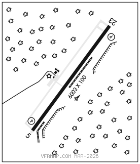
RWY 05–23: H6003X100 (ASPH) S–70, D–95 MIRL
RWY 05: REIL. PAPI(P4L)–GA 3.0° TCH 28′. Brush.
RWY 23: REIL. PAPI(P4L)–GA 3.0° TCH 46′. Trees.
SERVICE: S4 FUEL 100LL, JET A1+ OX 3 LGT ACTVT REIL Rwy 05 and 23–CTAF. MIRL Rwy 05–23 on until midnight. After midnight, ACTVT MIRL Rwy 05–23–CTAF.
NOISE: Noise abatement procedures in effect, call amgr 910–296–2188.
AIRPORT REMARKS: Attended Mon–Fri 1200–2300Z‡, Sat 1300–2300Z‡, Sun 1800–2300Z‡. Unattended Thanksgiving and Christmas. Deer, dogs, birds on and invof arpt. Arpt CLOSED to mil acft exc 1 hr PPR. Mil acft land forward of numbers and limit delay on rwy to avoid damage to rwy surfaces. Duplin Co Arpt CLOSED to touch and go/practice apchs 0200–1100Z‡. (All other times touch and go/practice apchs ltd to 30 minutes each).
AIRPORT MANAGER: 910-296-2188
WEATHER DATA SOURCES: AWOS–3 120.675 (910) 296–9688.
COMMUNICATIONS: CTAF/UNICOM 123.0
®SEYMOUR JOHNSON APP/DEP CON 119.7 (1200–0400Z‡)
®WASHINGTON CENTER APP/DEP CON 123.85 (0400–1200Z‡)
RADIO AIDS TO NAVIGATION: NOTAM FILE ISO.
KINSTON (VL) (L) VORTAC 117.5 ISO Chan 122 N35°22.26′ W77°33.50′ 228° 30.4 NM to fld. 705W.
VOR unusable:
020°–025° byd 40 NM
040°–115° byd 40 NM
145°–155° byd 40 NM
175°–185° byd 40 NM
183°–215° byd 30 NM blo 5,000′
200°–206° byd 40 NM
207°–214° byd 59 NM
215°–238° blo 3,500′
215°–238° byd 6 NM
238°–258° byd 30 NM blo 5,000′
239°–265° byd 40 NM
280°–290° byd 40 NM
295°–308° byd 40 NM
309°–319° byd 31 NM
320°–325° byd 40 NM
335°–340° byd 40 NM
345°–347° byd 40 NM
348°–358° byd 20 NM
TACAN AZIMUTH unusable:
183°–215° byd 30 NM blo 5,000′
DME unusable:
183°–215° byd 30 NM blo 5,000′