DENISON MUNI (DNS)(KDNS) 2 SW UTC–6(–5DT) N41°59.17′ W95°22.82′
1274 B NOTAM FILE DNS
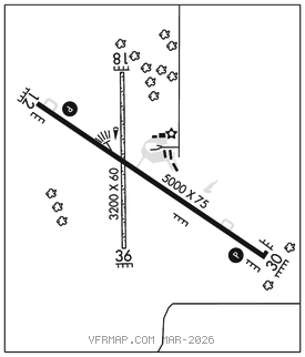
RWY12–30:H5000X75 (CONC) S–28, D–48 PCN 9 R/C/W/T MIRL 0.3% up NW
RWY 12: REIL. PAPI(P2L)–GA 3.0° TCH 28′.
RWY 30: REIL. PAPI(P2L)–GA 3.5° TCH 40′. Ground.
RWY 18–36: 3200X60 (TURF)
SERVICE: FUEL 100LL, JET A LGT MIRL Rwy 12–30 preset on low ints, to increase ints and ACTIVATE PAPI Rwy 12 and Rwy 30, REIL Rwy 12 and Rwy 30–CTAF.
AIRPORT REMARKS: Attended Mon–Fri 1400–2300Z‡ after 2300Z‡, call 712–210–1900. Rwy 18–36 CLOSED Nov–Apr. Rwy 18–36 rough surface. For fuel call arpt manager 712–263–6424 or (cell) 712–210–1900. Caution for wildlife in vicinity. Rwy 18 and Rwy 36 thlds and sides marked with yellow cones. Rwy 30 is calm wind rwy.
AIRPORT MANAGER: 712-263-6424
WEATHER DATA SOURCES: AWOS–3 119.95 (712) 263–6558.
COMMUNICATIONS: CTAF/UNICOM 122.8
RCO 122.4 (FORT DODGE RADIO)
®MINNEAPOLIS CENTER APP/DEP CON 119.6
CLEARANCE DELIVERY PHONE: For CD if una to ctc on FSS freq, ctc Minneapolis ARTCC at 651-463-5588.
RADIO AIDS TO NAVIGATION: NOTAM FILE SUX.
SIOUX CITY (L) TACAN Chan 112 SUX (116.5) N42°20.67′ W96°19.42′ 108° 47.3 NM to fld. 1087/9E.