DANIEL FLD (DNL)(KDNL) 1 W UTC–5(–4DT) N33°28.00′ W82°02.36′
422 B NOTAM FILE DNL
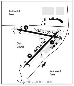
RWY 05–23: H4002X100 (ASPH–GRVD) S–30 MIRL 1.2% up NE
RWY 05: REIL. PAPI(P2L)–GA 3.0° TCH 30′. Thld dsplcd 202′. Tree.
RWY 23: REIL. PAPI(P2L)–GA 3.3° TCH 26′. Thld dsplcd 298′. Road.
RWY 11–29: H3733X100 (ASPH) S–30 MIRL
RWY 11: REIL. PAPI(P4L)–GA 3.5° TCH 54′. Thld dsplcd 326′. Road.
RWY 29: Thld dsplcd 314′. Road.
RUNWAY DECLARED DISTANCE INFORMATION
RWY 11: TORA–3733 TODA–3733 ASDA–3733 LDA–3407
RWY 29: TORA–3733 TODA–3733 ASDA–3733 LDA–3419
SERVICE: S4 FUEL 100LL, JET A1+ OX 1, 2, 3, 4 LGT ACTVT REIL Rwy 05, 11, 23; PAPI Rwy 05, 11, and 23; MIRL Rwys 05–23 and 11–29–CTAF. Rwy 11 PAPI unusbl byd 3° left of rwy cntrln, PAPI is baffled.
AIRPORT REMARKS: Attended 1200Z‡–dusk. Pilots should be alert for turbo–jet tfc transiting the tfc area enroute to Bush Field 6 miles south.
AIRPORT MANAGER: 706-733-8970
WEATHER DATA SOURCES: ASOS 135.275 (706) 481–8629.
COMMUNICATIONS: CTAF/UNICOM 123.05
RCO 122.3 (MACON RADIO)
®AUGUSTA APP/DEP CON 126.8 (1145–0400Z‡)
®ATLANTA CENTER APP/DEP CON 128.1 (0400–1145Z‡)
RADIO AIDS TO NAVIGATION: NOTAM FILE AND.
COLLIERS (VH) (H) VORTAC 113.9 IRQ Chan 86 N33°42.44′ W82°09.72′ 161° 15.7 NM to fld. 4204W.
EMORY NDB (HW) 385 EMR N33°27.77′ W81°59.81′ 280° 2.1 NM to fld. 161/4W. NOTAM FILE MCN. NDB unmonitored when Augusta ATCT closed.
COMM/NAV/WEATHER REMARKS: To obtain clearances and cancel flight plans from the ground ctc App Con.