CUSTER CO (CUT)(KCUT) 2 SW UTC–7(–6DT) N43°44.02′ W103°37.17′
5620 B NOTAM FILE CUT
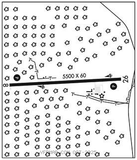
RWY 08–26: H5500X60 (ASPH) S–12.5 MIRL 1.3% up W
RWY 08: PAPI(P4L)–GA 3.0° TCH 40′.
RWY 26: PAPI(P4L)–GA 3.65° TCH 48′. Trees.
SERVICE: FUEL 100LL, JET A LGT Actvt MIRL Rwy 08–26; PAPI Rwy 08 and 26–CTAF. Airport beacon obscured radials 200°–260°.
AIRPORTREMARKS:Attended Mon–Fri 2200–0700Z‡. Fuel avbl 24 hrs with credit card. Strong crosswinds and windshear may exist on final under windy conditions. Be Alert: check density altitude and lean mixture for best operation at this altitude. 10′ wildlife fence around perimeter of arpt. Cfm winter conditions with amgr 605–858–1246. High vol of acft oprng invof of Mt. Rushmore and Crazy Horse Monuments at or blw 7500′; pilots are advised to mnt 122.85 for tfc advisories.
AIRPORT MANAGER: 605-673-3874
WEATHER DATA SOURCES: ASOS 120.00 (605) 206–3961.
COMMUNICATIONS: CTAF/UNICOM 122.8
CLEARANCE DELIVERY PHONE: For CD ctc Ellsworth Apch at 605-385-6198, when Apch clsd ctc Denver ARTCC at 303-651-4257.
RADIO AIDS TO NAVIGATION: NOTAM FILE RAP.
RAPID CITY (VH) (H) VORTAC 112.3 RAP Chan 70 N43°58.56′ W103°00.74′ 228° 30.1 NM to fld. 3157/13E.
VOR unusable:
215°–232° byd 40 NM
233°–243° byd 40 NM blo 8,300′
233°–243° byd 81 NM blo 18,000′
244°–253° byd 40 NM blo 8,000′
244°–253° byd 61 NM
254°–264° byd 40 NM blo 18,000′