CONCORDIA
BLOSSER MUNI (CNK)(KCNK) 2 S UTC–6(–5DT) N39°32.99′ W97°39.12′ 1488 B NOTAM FILE CNK
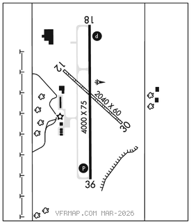
RWY 18–36: H4000X75 (ASPH) S–8, D–10 PCN 5 F/C/Y/U MIRL 0.3% up S
RWY 18: REIL. PAPI(P4L)–GA 3.0° TCH 35′.
RWY 36: REIL. PAPI(P4L)–GA 3.0° TCH 40′.
RWY 12–30: 2040X60 (TURF) 0.7% up NW
RWY 12: Pole.
RWY 30: Fence.
SERVICE: FUEL 100LL, JET A+ LGT ACTVT REIL Rwy 18 and 36; PAPI Rwy 18 and 36–CTAF. MIRL Rwy 18–36 preset med intst dusk–0400Z‡; aft 0400Z‡ ACTVT–CTAF. Rwy 18 PAPI unusbl byd 4 degs left of cntrln. Rwy 36 PAPI unusbl byd 6 degs left of cntrln.
AIRPORT REMARKS: Attended Mon–Fri 1400–2200Z‡. Rdo ctl model airplane to 400 ft east; evening, wkend, and hol. Fuel avbl H24 hrs by credit card.
AIRPORT MANAGER: 785-243-2670
WEATHER DATA SOURCES: ASOS 123.825 (785) 262–9693.
COMMUNICATIONS: CTAF/UNICOM 122.8
®KANSAS CITY CENTER APP/DEP CON 134.9
CLEARANCE DELIVERY PHONE: For CD ctc Kansas City ARTCC at 913-254-8508.
RADIO AIDS TO NAVIGATION: NOTAM FILE ICT.
MANKATO (L) TACAN Chan 35 TKO (109.8) N39°48.38′ W98°15.60′ 108° 32.1 NM to fld. 188010E.