CANTON
CHEROKEE CO RGNL (CNI)(KCNI) 6 NE UTC–5(–4DT) N34°18.73′ W84°25.33′ 1219 B NOTAM FILE MCN
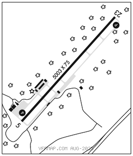
RWY 05–23: H5003X75 (ASPH) S–26 MIRL 0.3% up NE
RWY 05: REIL. PAPI(P4L)–GA 3.0° TCH 26′.
RWY 23: REIL. PAPI(P4L)–GA 3.0° TCH 33′. Trees.
SERVICE: S4 FUEL 100LL, JET A+ OX 1, 2, 3, 4 LGT ACTVT REIL Rwy 05 and Rwy 23; PAPI Rwy 05 and Rwy 23; MIRL Rwy 05–23–CTAF.
NOISE: For noise abatement Rwy 23 pref.
AIRPORT REMARKS: Attended 1300–2300Z‡.
AIRPORT MANAGER: 678-454-2090
WEATHER DATA SOURCES: AWOS–3PT 119.825 (678) 454–2065.
COMMUNICATIONS: CTAF/UNICOM 123.0
®ATLANTA APP/DEP CON 121.0 for acft arr and dep from the north, ctc Atlanta ARTCC at 770–210–7692. For Apch/Dep svc for acft arr and dep from the south, ctc Atlanta ARTCC at 678–364–6131.
RADIO AIDS TO NAVIGATION: NOTAM FILE RMG.
ROME (VH) (H) VORTACW 115.4 RMG Chan 101 N34°09.75′ W85°07.16′ 074° 35.8 NM to fld. 1148/1E.
COMM/NAV/WEATHER REMARKS: Rdo transmissions from the dep end of Rwy 23 may not be relbl due to trrn.