CARO
TUSCOLA AREA (CFS)(KCFS) 3 SW UTC–5(–4DT) N43°27.53′ W83°26.73′ 704 B NOTAM FILE CFS
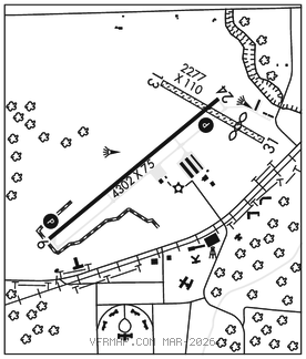
RWY 06–24: H4302X75 (ASPH) MIRL 0.4% up NE
RWY 06: PAPI(P4L)–GA 3.0° TCH 40′. Tree.
RWY 24: PAPI(P4L)–GA 3.5° TCH 48′. Tree.
RWY 13–31: 2277X110 (TURF) 0.7% up NW
RWY 13: Brush.
RWY 31: Thld dsplcd 564′. Tree.
SERVICE: S4 FUEL 100LL, JET A+ LGT ACTVT PAPI Rwy 06 & 24; MIRL Rwy 06–24–CTAF. PAPI Rwy 06 and 24 opr consly dawn–dusk. Rwy 06 PAPI unusbl byd 9 degs left of cntrln.
AIRPORT REMARKS: Attended irregularly. Deer and large birds on and invof arpt. Remote ctl acft ops south of rwy int. Rwy 13 mkd with 3′ yellow cones.
AIRPORT MANAGER: 989-670-2441
WEATHER DATA SOURCES: AWOS–3P 119.275 (989) 672–4182.
COMMUNICATIONS: CTAF/UNICOM 123.0
®GREAT LAKES APP/DEP CON 120.95 (1030–0500Z‡)
®CLEVELAND CENTER APP/DEP CON 127.7 when Great Lakes apch ctl clsd.
CLEARANCE DELIVERY PHONE: For CD ctc Great Lakes Apch at 269-459-3345, when Apch clsd ctc Cleveland ARTCC at 440-774-0224/0490.
RADIO AIDS TO NAVIGATION: NOTAM FILE MBS.
SAGINAW (VL) (DH) VORW/DME 114.35 MBS Chan 90(Y) N43°31.90′ W84°04.64′ 102° 27.9 NM to fld. 663/3W.
DME unusable:
185°–200° byd 14 NM
VOR unusable:
145°–185° byd 40 NM
336°–338° byd 40 NM