CEDAR CITY RGNL (CDC)(KCDC) 2 NW UTC–7(–6DT) N37°42.06′ W113°05.93′
5622 B TPA–6399(777) Class I, ARFF Index A NOTAM FILE CDC MON Airport
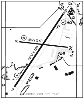
RWY 02–20: H8653X150 (ASPH–GRVD) S–56, D–76, 2S–127, 2D–127, 2D/2D2–142 PCR 410 F/B/X/T HIRL
RWY 02: REIL. PAPI(P4L)–GA 3.0° TCH 48′. 0.4% up.
RWY 20: MALSR. PAPI(P4L)–GA 3.0° TCH 50′. Rgt tfc.
RWY 08–26: H4822X60 (ASPH) S–16 PCR 40 F/B/X/T MIRL 0.9% up E
RWY 08: REIL. PAPI(P4L)–GA 3.0° TCH 47′. Pole.
RWY 26: REIL. Road. Rgt tfc.
RUNWAY DECLARED DISTANCE INFORMATION
RWY 02: TORA–8653 TODA–8653 ASDA–8653 LDA–8653
RWY 08: TORA–4822 TODA–4822 ASDA–4822 LDA–4822
RWY 20: TORA–8653 TODA–8653 ASDA–8653 LDA–8653
RWY 26: TORA–4822 TODA–4822 ASDA–4822 LDA–4822
SERVICE: S4 FUEL 100LL, JET A OX3, 4 LGT ACTVT MALSR Rwy 20, REIL Rwy 02, Rwy 08 and Rwy 26, HIRL Rwy 02–20, MIRL Rwy 08–26–CTAF. PAPI Rwy 02 and Rwy 20, Rwy 08 opr consly.
AIRPORT REMARKS: Attended dalgt hrs. For after hrs svc call 435–586–4504. 100LL fuel avbl 24 hrs self–svc credit card system. Unmon sfc conds 0200–1400Z‡ dly exc for sked acr. Extensive helicopter activity. Extensive flight training invof arpt. CLOSED to unscheduled air carrier ops with more than 30 passenger seats except 24 hr PPR call Cedar City Fire department 435–586–2964 arpt manager 435–867–9408. General Aviation acft not permitted on Air Carrier ramp. Rwy 08–26 and Twy B not avbl for acr acft. Designated calm wind rwy (blo 5 knots) is Rwy 20, rgt tfc. Recommend pilots circle arpt for altitude before departing eastbound due to fast rising terrain and high density altitude. Turbulence likely invof mountains and passes. No autorotation trng to helipad. Rwy 02–20 clsd to heli run–on ldg; Rwy 08–26 clsd to heli run–on ldg; Twy A, N of Rwy 08–26 clsd to hel run–on lndg; Twy C clsd to hel run–on lndg. Twy B clsd btwn C and east apron. Rwy 02 left traffic pattern exc helicopters. Rwy 20 right traffic exc helicopters. NOTE: See Special Notices–Extensive Flight Training in vicinity of Cedar City Municipal Airport.
AIRPORT MANAGER: 435-867-9408
WEATHER DATA SOURCES: ASOS 119.025 (435) 867–0278.
COMMUNICATIONS: CTAF/UNICOM 123.0
RCO 122.2 122.3 (CEDAR CITY RADIO)
®SALT LAKE CENTER APP/DEP CON 125.575
CLEARANCE DELIVERY PHONE: For CD if una to ctc on FSS freq, ctc Salt Lake ARTCC at 801-320-2568.
AIRSPACE: CLASS E.
RADIO AIDS TO NAVIGATION: NOTAM FILE CDC.
ENOCH (VH) (DH) VORW/DME 117.3 EHK Chan 120 N37°47.24′ W113°04.09′ 180° 5.4 NM to fld. 5464/16E.
VOR unusable:
055°–088° byd 20 NM
088°–135° byd 10 NM blo 13,500′
088°–135° byd 15 NM
135°–175° byd 20 NM
176°–180° byd 40 NM
181°–191° byd 40 NM blo 19,000′
181°–191° byd 62 NM
192°–292° byd 40 NM
215°–255° byd 35 NM blo 10,500′
297°–315° byd 40 NM
324°–333° byd 40 NM
342°–054° byd 40 NM
DME unusable:
088°–135° byd 10 NM blo 13,500′
088°–135° byd 15 NM
135°–175° byd 20 NM
215°–255° byd 35 NM blo 10,500′
ILS 110.1 I–ECC Rwy 20. Class IE.