CAMBRIDGE MUNI (CBG)(KCBG) 2 SW UTC–6(–5DT) N45°33.45′ W93°15.85′
945 B NOTAM FILE CBG
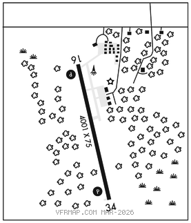
RWY 16–34: H4001X75 (ASPH) S–12.5 MIRL
RWY 16: PAPI(P4R)–GA 3.0° TCH 37′.
RWY 34: REIL. PAPI(P4L)–GA 3.0° TCH 41′. Trees.
SERVICE: FUEL 100LL, JET A LGT ACTVT or incr intst REIL Rwy 34; PAPI Rwy 16 and 34; MIRL Rwy 16–34–CTAF. MIRL Rwy 16–34 preset low intst SS–SR.
NOISE: For Noise Abatement Rwy 16 deps fly rwy hdg to 1945′ MSL (1000′ AGL) and 2 NM bfr left turn.
AIRPORTREMARKS: Unattended. Migratory waterfowl and deer on and invof arpt. Fuel avbl H24 self ser via credit card. Code for AD bldg: last 3 digits of emerg freq.
AIRPORT MANAGER: 763-552-3279
WEATHER DATA SOURCES: AWOS–3PT 121.125 (763) 689–9562.
COMMUNICATIONS: CTAF/UNICOM 122.8
®MINNEAPOLIS CENTER APP/DEP CON 121.05
CLEARANCE DELIVERY PHONE: For CD ctc Minneapolis ARTCC at 651-463-5588.
RADIO AIDS TO NAVIGATION: NOTAM FILE PNM.
GOPHER (VH) (H) VORTACW 117.3 GEP Chan 120 N45°08.74′ W93°22.39′ 005° 25.1 NM to fld. 877/6E.
VOR unusable:
025°–080° blo 5,000′
061°–071° byd 40 NM
067°–080° byd 47 NM blo 3,000′
067°–080° byd 70 NM blo 12,000′
239°–277° byd 40 NM blo 18,000′
240°–260° byd 5 NM
275°–285° byd 10 NM blo 4,000′
330°–345° byd 13 NM blo 3,000′
TACAN AZIMUTH unusable:
025°–080° blo 5,000′
145°–155° byd 37 NM blo 3,800′
230°–250° byd 38 NM blo 3,400′
275°–285° byd 10 NM blo 4,000′
330°–345° byd 13 NM blo 3,000′
DME unusable:
145°–155° byd 37 NM blo 3,800′
275°–285° byd 10 NM blo 4,000′
330°–345° byd 13 NM blo 3,000′