BEAVER FALLS
BEAVER CO (BVI)(KBVI) 3 NW UTC–5(–4DT) N40°46.35′ W80°23.49′ 1253 B NOTAM FILE BVI
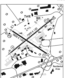
RWY 10–28: H4501X100 (ASPH–GRVD) S–16, D–32 MIRL 1.1% up E
RWY 10: REIL. PAPI(P4L)–GA 3.0° TCH 42′. Trees.
RWY 28: REIL. PAPI(P4L)–GA 3.0° TCH 43′. Trees.
SERVICE: S4 FUEL 100LL, JET A, A+ LGT Twr ctl. When ATCT clsd MIRL Rwy 10–28 and twy lgts oper low intst. Incr intst and ACTVT REIL Rwy 10 and 28–CTAF. PAPI Rwy 10 and Rwy 28 oper cont. Rwy 28 REILS OTS indefly.
NOISE: Noise abatement procedures in effect for deps only, ctc arpt manager 1300–2100Z‡ for details at 724–847–4662.
AIRPORT REMARKS: Attended Mon–Fri 1200–0200Z‡, Sat–Sun 1400–2100Z‡. Unattended all federal holidays.
AIRPORT MANAGER: 724-847-4662
WEATHER DATA SOURCES: AWOS–3PT 118.35 (724) 843–1024.
COMMUNICATIONS: CTAF 120.3 ATIS 118.35
ELLWOOD CITY RCO 122.1R 115.8T (ALTOONA RADIO)
®PITTSBURGH APP/DEP CON 124.75
TOWER 120.3 (1230–0030Z‡ Mon–Fri; clsd Sat–Sun)
GND CON 121.8 CLNC DEL 124.85 (when twr clsd)
AIRSPACE: CLASS D svc 1230–0030Z‡ Mon–Fri, clsd Sat–Sun; other times CLASS G.
RADIO AIDS TO NAVIGATION: NOTAM FILE AOO.
ELLWOOD CITY (VH) (H)VOR/DME 115.8 EWC Chan 105 N40°49.50′ W80°12.69′ 257° 8.8 NM to fld. 1227/8W.
VOR unusable:
285°–335°
LOC 109.3 I–BVI Rwy 10. LOC unmonitored when ATCT clsd
COMM/NAV/WEATHER REMARKS: Emerg frequency 121.5 not available at twr.