BURLINGTON/ALAMANCE RGNL (BUY)(KBUY) 3 SW UTC–5(–4DT) N36°02.98′ W79°28.38′
616 B NOTAM FILE BUY MON Airport
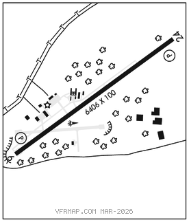
RWY 06–24: H6406X100 (ASPH) S–73, D–97, 2D–57 PCN 29 F/C/W/T HIRL 0.5% up SW
RWY 06: REIL. PAPI(P4L)–GA 3.0° TCH 45′. Trees.
RWY 24: REIL. PAPI(P4L)–GA 3.0° TCH 59′. Trees.
SERVICE: S4 FUEL 100LL, JET A1+ OX 3 LGT ACTVT REIL Rwys 06 and 24–CTAF. PAPI Rwy 06 and 24 oper cont. HIRL Rwy 06–24 on dusk–dawn, to change intst–CTAF.
AIRPORTREMARKS:Attended 1300–0100Z‡. Unatndd Christmas Day. Deer and waterfowl invof arpt. After hrs fuel or emerg only 336–223–4994. Rwy 06, 15 ft drop–off 150 ft fm thr 250 ft left of cntrln. Rwy 24 has unmkd high voltage transmission lines aprxly 4000 ft from thr and both sides of cntrln.
AIRPORT MANAGER: 336-227-0771
WEATHER DATA SOURCES: ASOS 135.325 (336) 570–9813.
COMMUNICATIONS: CTAF/UNICOM 122.975
®GREENSBORO APP/DEP CON 126.6
CLNC DEL 120.25
CLEARANCEDELIVERY PHONE:For CD ctc Greensboro Apch at 743-222-6129.
RADIO AIDS TO NAVIGATION: NOTAM FILE RDU.
LIBERTY (VL) (L) VORTAC 113.0 LIB Chan 77 N35°48.70′ W79°36.76′ 028° 15.8 NM to fld. 828/3W.
ALAMM NDB (MHW/LOM) 361 HB N35°58.69′ W79°35.09′ 060° 6.9 NM to fld. 684/8W. NOTAM FILE BUY.
ILS 111.35 I–HBJ Rwy 06. Class IE. ILS unmnt.