BOYNE FALLS
BOYNE MOUNTAIN (BFA)(KBFA) 1 W UTC–5(–4DT) N45°09.95′ W84°55.45′ 719 NOTAM FILE BFA
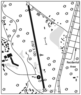
RWY 17–35: H5187X100 (ASPH–GRVD) MIRL 0.3% up S
RWY 17: REIL. Thld dsplcd 300′. Road.
RWY 35: REIL. PAPI(P2L)–GA 3.0° TCH 40′. Thld dsplcd 500′. Trees.
SERVICE: FUEL 100LL LGT ACTVT REIL Rwy 17 & 35; PAPI Rwy 35; MIRL Rwy 17–35–CTAF.
AIRPORT REMARKS: Unattended. Deer, birds and wildlife on & invof arpt. Pedestrians invof rwy environment. 100LL avbl self svc via credit card. For ldg fees ctc AMGR for details. Rwy 17–35 trees, bldgs, and roads in pri sfc.
AIRPORT MANAGER: 231-549-6852
WEATHER DATA SOURCES: AWOS–3PT 118.675 (231) 330–8677.
COMMUNICATIONS: CTAF/UNICOM 122.8
®MINNEAPOLIS CENTER APP/DEP CON 134.6
CLEARANCE DELIVERY PHONE: For CD ctc Minneapolis ARTCC at 651-463-5588.
RADIO AIDS TO NAVIGATION: NOTAM FILE PLN.
PELLSTON (L) (L) VORTACW 111.8 PLN Chan 55 N45°37.84′ W84°39.85′ 208° 30.0 NM to fld. 836/6W.
VOR unusable:
301°–339°
GCP has azm only, no DME at GCP