BROKEN BOW MUNI/KEITH GLAZE FLD (BBW)(KBBW) 2 N UTC–6(–5DT) N41°26.19′ W99°38.53′
2546 B NOTAM FILE BBW
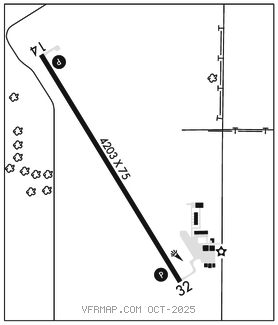
RWY 14–32: H4203X75 (CONC) S–30 MIRL 0.6% up NW
RWY 14: REIL. PAPI(P2L)–GA 3.0° TCH 40′. Road.
RWY 32: PAPI(P2L)–GA 3.0° TCH 40′.
SERVICE: FUEL 100LL, JET A LGT ACTIVATE REIL Rwy 14; PAPI Rwy 14 & 32; MIRL Rwy 14–32–CTAF.
AIRPORT REMARKS: Unattended. For svc call numbers listed on notice in terminal building. JET A avbl by prior arrangement. 24 hrs self svc fuel avbl via credit card system for 100LL. Courtesy car and van avbl.
AIRPORT MANAGER: 308-872-2875
WEATHER DATA SOURCES: ASOS 120.0 (308) 872–5354.
COMMUNICATIONS: CTAF/UNICOM 122.8
®DENVER CENTER APP/DEP CON 132.7
CLEARANCE DELIVERY PHONE: For CD ctc Denver ARTCC at 303-651-4257.
RADIO AIDS TO NAVIGATION: NOTAM FILE BBW.
CUSTER COUNTY (L) (L) VORW/DME 108.2 CUZ Chan 19 N41°29.04′ W99°41.34′ 135° 3.5 NM to fld. 2842/8E.