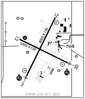
APPLETON INTL (ATW)(KATW) 3 W UTC–6(–5DT) N44°15.49′ W88°31.14′
918 B Class I, ARFF Index B NOTAM FILE ATW

RWY 03–21: H8003X150 (CONC–GRVD) S–120, D–250, 2S–175, 2D–524, 2D/2D2–1043 PCR 1000 R/C/W/T HIRL
RWY 03: MALSR. PAPI(P4L)–GA 3.0° TCH 47′. RVR–T Tree.
RWY 21: REIL. PAPI(P4L)–GA 3.0° TCH 47′. RVR–R Tree.
RWY 12–30: H6502X150 (CONC–GRVD) S–120, D–224, 2S–175, 2D–360, 2D/2D2–835 PCR 730 R/C/W/T HIRL 0.9% up NW
RWY 12: REIL. PAPI(P4L)–GA 3.0° TCH 35′. Tree.
RWY 30: MALSR. PAPI(P4L)–GA 3.0° TCH 61′.
LAND AND HOLD–SHORT OPERATIONS
LDG RWY HOLD–SHORT POINT AVBL LDG DIST
RWY 03 12–30 3300
RWY 21 12–30 4100
RWY 30 03–21 3400
RUNWAY DECLARED DISTANCE INFORMATION
RWY 03: TORA–8002 TODA–8002 ASDA–8002 LDA–8002
RWY 12: TORA–6501 TODA–6501 ASDA–6501 LDA–6501
RWY 21: TORA–8002 TODA–8002 ASDA–8002 LDA–8002
RWY 30: TORA–6501 TODA–6501 ASDA–6501 LDA–6501
SERVICE: S4 FUEL 100LL, JET A OX 1, 2 LGT When twr clsd HIRL Rwy 03–21 preset on low ints, to increase ints and ACTIVATE MALSR Rwy 03 and Rwy 30; REIL Rwy 12 and Rwy 21; PAPI Rwy 12, HIRL Rwy 03–21 and Rwy 12–30–CTAF. PAPI Rwy 03, Rwy 21 and Rwy 30 opr continuously. Rwy 21 PAPI rstd byd 8.5° right of course.
AIRPORT REMARKS: Attended continuously. Birds and migratory waterfowl on and invof arpt. Snow removal ops in progress winter months. Vehicle operators will be monitoring CTAF; acft ldg/dep Appleton should use CTAF when twr clsd. Periodic live fire trng south side of arpt. US CSTMS and Border Protection, PPR US CSTMS svc Mon–Fri 1300–2100Z (0800–1600 local) call 920–968–2348. Coml ramp deicing pads are avbl for live eng run opn drg deicing.User fee arpt.
AIRPORT MANAGER: 920-832-5267
WEATHER DATA SOURCES: AWOS–3 (920) 832–2597 LAWRS.
COMMUNICATIONS: CTAF 119.6 ATIS 127.15 UNICOM 122.95
®GREEN BAY APP/DEP CON 126.3 (1130–0530Z‡)
®MINNEAPOLIS CENTER APP/DEP CON 126.3 (0530–1130Z‡)
APPLETON TOWER 119.6 (1130–0500Z‡) GND CON 121.7
CLEARANCE DELIVERY PHONE: When ATCT clsd, for CD ctc Green Bay Apch on freq, if una ctc Minneapolis ARTCC at 651-463-5588.
AIRSPACE: CLASS D svc 1130–0500Z‡; other times CLASS G.
RADIO AIDS TO NAVIGATION: NOTAM FILE OSH.
OSHKOSH (VL) (H) VORTAC 116.75 OSH Chan 114(Y) N43°59.43′ W88°33.36′ 004° 16.1 NM to fld. 782/2E.
TACAN AZIMUTH unusable:
166°–174° byd 10 NM
DME unusable:
012°–018° byd 38 NM
145°–175°
196°–257° byd 35 NM blo 3,000′
VOR unusable:
010°–020° byd 40 NM
155°–160° byd 40 NM
185°–265° byd 40 NM
199°–250° byd 35 NM blo 3,000′
KOOKY NDB (LOMW) 407 AQ N44°12.96′ W88°23.94′ 298° 5.8 NM to fld. 752/2W. NOTAM FILE ATW. NDB unmonitored.
ILS/DME 109.1 I–ATW Chan 28 Rwy 03. Class 1C. ILS/unmonitored when ATCT clsd. LOC unusable byd 20° right of course. DME unusable byd 25° right of course.
ILS/DME 109.7 I–AQZ Chan 34 Rwy 30. Class IT. LOM KOOKY NDB. ILS/DME unmonitored.