WASHINGTON CO (AFJ)(KAFJ) 3 SW UTC–5(–4DT) N40°08.19′ W80°17.41′
1184 B NOTAM FILE AFJ
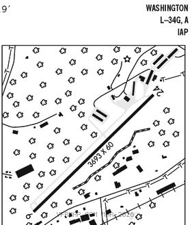
RWY 09–27: H5004X100 (ASPH) S–40, D–60, 2D–90 HIRL
RWY 09: PAPI(P4L)–GA 3.71° TCH 85′. Trees.
RWY 27: REIL. PAPI(P4L)–GA 3.09° TCH 62′. Trees.
SERVICE: S4 FUEL 100LL, JET A, A+ OX 1, 3 LGT ACTVT REIL Rwy 27; HIRL Rwy 09–27–CTAF. Rwy 09 PAPI unusbl byd 7 degs right of cntrln.
AIRPORT REMARKS: Attended Mon–Fri 1200–0000Z‡, Sat–Sun 1200–2200Z‡. Birds on and invof rwy. 208 ft hill and trees 2937 ft fm thld Rwy end 09. 226 ft hill and trees 2941 ft fm thld Rwy end 09. 288 ft hill and trees 7238 ft fm thld Rwy end 27. 268 ft hill and trees 8091 ft fm thld Rwy end 27. 158 ft obstr lit pole approx 3389 ft fm thld Rwy end 09. 159 ft obstr lit pole approx 3055 ft fm thld Rwy end 09.
AIRPORT MANAGER: 724-228-5151
WEATHER DATA SOURCES: AWOS–3PT 119.175 (724) 228–3529.
COMMUNICATIONS: CTAF/UNICOM 122.975
®PITTSBURGH APP/DEP CON 119.35
CLNC DEL 127.3
RADIO AIDS TO NAVIGATION: NOTAM FILE AGC.
ALLEGHENY (L) (L) VORW/DME 110.0 AGC Chan 37 N40°16.72′ W80°02.45′ 242° 14.3 NM to fld. 1285/9W.
VOR unusable:
036°–059° byd 10 NM blo 7,000′
071°–175°
226°–261° byd 10 NM
300°–310°
WHEELING (L) (L) VORW/DME 114.25 HLG Chan 89(Y) N40°15.59′ W80°34.12′ 127° 14.8 NM to fld. 1269/7W. NOTAM FILE HLG.
VOR unusable:
005°–045°
105°–190° byd 7 NM
315°–320° blo 3,000′
ILS/DME 110.3 I–AFJ Chan 40 Rwy 27. Glideslope unusable byd 5° left of course.