CAMPBELLSVILLE
TAYLOR CO (AAS)(KAAS) 2 NE UTC–5(–4DT) N37°21.50′ W85°18.57′ 921 B NOTAM FILE LOU
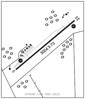
RWY 05–23: H5004X75 (ASPH) S–37, D–49 PCN 14 F/D/X/T MIRL 1.0% up NE
RWY 05: REIL. PAPI(P4L)–GA 3.5° TCH 48′. Trees.
RWY 23: REIL. PAPI(P4L)–GA 3.25° TCH 40′. Trees.
SERVICE: S6 FUEL 100LL, JET A+ LGT ACTVT REIL Rwy 05 and 23; PAPI Rwy 05 and 23–CTAF; MIRL Rwy 05–23 preset on low intst; incr intst–CTAF.
AIRPORT REMARKS: Attended Mon–Fri 1300–2200Z‡. Aft hr 270–469–0133/270–789–7700. 100LL avbl aft hr with credit card.
AIRPORT MANAGER: 270-789-4182
WEATHER DATA SOURCES: AWOS–3 121.125 (270) 789–1985.
COMMUNICATIONS: CTAF/UNICOM 122.7
®INDIANAPOLIS CENTER APP/DEP CON 124.625
CLEARANCE DELIVERY PHONE: For CD ctc Indianapolis ARTCC at 317-247-2411.
RADIO AIDS TO NAVIGATION: NOTAM FILE LOU.
NEW HOPE (L) (L) VORW/DME 113.95 EWO Chan 86(Y) N37°37.91′ W85°40.55′ 132° 24.0 NM to fld. 9601E.
VOR unusable:
125°–135° blo 3,000′